Home > Arts > Artists > L > Antoine Lafrery
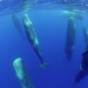
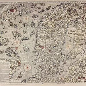
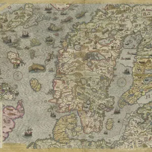
Detail of A Map of the Sea (Carta marina) by Olaus Magnus (1490-1557), 1572 (engraving)
 by Olaus Magnus (1490-1557), 1572 (engraving)")
![]()
Wall Art and Photo Gifts from Fine Art Finder
Detail of A Map of the Sea (Carta marina) by Olaus Magnus (1490-1557), 1572 (engraving)
7394859 Detail of A Map of the Sea (Carta marina) by Olaus Magnus (1490-1557), 1572 (engraving) by Lafrery, Antoine (1512-77); Private Collection; (add.info.: The Carta marina of the Swedish geographer and historian Olaus Magnus (1490-1557) is one of the earliest accurate cartographic depictions of the Scandinavian peninsula. This is the second edition of this map, published by Antoine Lafréry in 1572.)
Media ID 32114642
© Bridgeman Images
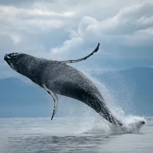
Aquatic Mammal Baltics C16h Compass Compass Card Estonia Fantastic Animal Fantastic Creature Fantastic Creatures Finland Geographer Humpback Whale Islands Isles Latvia Lithuania Marine Mammal Marine Mammals Mythical Animal Mythical Beast Mythical Creature Mythical Creatures North Sea Norway Sea Mammal Seas Seawater Sverige Sweden Swedish Tool Whale World Map 16 16th Xvi Xvith Sixteenth Century
FEATURES IN THESE COLLECTIONS
> Animals
> Aquatic
> Cetacea
> Whale
> Animals
> Aquatic
> Related Images
> Animals
> Mammals
> Balaenopteridae
> Humpback Whale
> Animals
> Mammals
> Humpback Whale
> Animals
> Mammals
> Muridae
> Magnus
> Arts
> Artists
> L
> Antoine Lafrery
> Europe
> Estonia
> Related Images
> Fine Art Finder
> Artists
> Antoine Lafrery
EDITORS COMMENTS
This print showcases a mesmerizing detail of "A Map of the Sea (Carta marina)" by Olaus Magnus, an esteemed Swedish geographer and historian from the 16th century. Published in 1572 by Antoine Lafréry, this engraving is a remarkable representation of the Scandinavian peninsula during that era. The map itself is a testament to Magnus' meticulous cartographic skills, as it stands as one of the earliest accurate depictions of Scandinavia. Its vibrant colors bring life to the various islands and coastlines that dot the North Sea, while also highlighting important geographical features with precision. Amidst this intricate landscape emerges a mythical creature—a fantastic beast that captures our imagination. This enchanting being adds an element of wonder and mystery to an already awe-inspiring artwork. As we explore further, we encounter other marine mammals such as humpback whales gracefully swimming through these waters. The presence of ships sailing across vast expanses hints at the maritime significance of this region during Magnus' time. The compass card serves as a reminder of navigational tools used by seafarers who relied on their knowledge and expertise to traverse these treacherous seas. Overall, this print allows us to delve into history and marvel at both human ingenuity in cartography and nature's wonders within our oceans. It serves as a visual portal connecting us with past explorations while igniting our curiosity for what lies beyond those distant shores.
MADE IN THE USA
Safe Shipping with 30 Day Money Back Guarantee
FREE PERSONALISATION*
We are proud to offer a range of customisation features including Personalised Captions, Color Filters and Picture Zoom Tools
SECURE PAYMENTS
We happily accept a wide range of payment options so you can pay for the things you need in the way that is most convenient for you
* Options may vary by product and licensing agreement. Zoomed Pictures can be adjusted in the Cart.