Home > Arts > Artists > S > Pieter Schenk
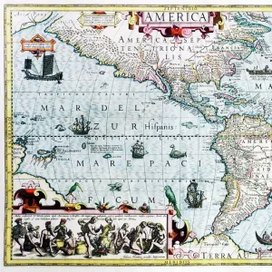
Map of Brazil, by Dutch cartographer Johannes Willemszoon Blaeu, published in Amsterdam 1662 by Pieter Schenk

![]()
Wall Art and Photo Gifts from Design Pics
Map of Brazil, by Dutch cartographer Johannes Willemszoon Blaeu, published in Amsterdam 1662 by Pieter Schenk
Design Pics offers Distinctively Different Imagery representing over 1,500 contributors
Media ID 24901496
© Ken Welsh / Design Pics
17th Century Cartography Geographical Geography South America South American 1662 Joan Blaeu Johannes Willemszoon Blaeu
FEATURES IN THESE COLLECTIONS
> Arts
> Artists
> B
> Joan Blaeu
> Arts
> Artists
> S
> Pieter Schenk
> Maps and Charts
> Early Maps
> Maps and Charts
> Related Images
> South America
> Brazil
> Maps
> South America
> Brazil
> Related Images
EDITORS COMMENTS
This print showcases a remarkable piece of history - the Map of Brazil, meticulously crafted by the renowned Dutch cartographer Johannes Willemszoon Blaeu in 1662. Published in Amsterdam by Pieter Schenk, this map offers a fascinating glimpse into the geographical and historical landscape of Brazil during the 17th century. With its intricate details and exquisite illustrations, this archival treasure takes us on a journey through time. It serves as an invaluable resource for those interested in exploring Brazil's rich cultural heritage and understanding its geographical evolution over centuries. The Map of Brazil is not just a mere representation of landmasses; it tells stories of exploration, colonization, and trade routes that shaped South America during this era. Its delicate craftsmanship reflects Blaeu's mastery in cartography, capturing every contour with precision and artistry. As we gaze upon this old-world gem, we are transported to an era when maps were hand-drawn works of art that blended science with imagination. The Welsh-born Blaeu's expertise shines through his attention to detail and dedication to accuracy. This print is more than just an illustration or geography lesson; it is a testament to human curiosity and our relentless pursuit to understand the world around us. Let it inspire you to delve deeper into history or simply marvel at the beauty encapsulated within these ancient lines.
MADE IN THE USA
Safe Shipping with 30 Day Money Back Guarantee
FREE PERSONALISATION*
We are proud to offer a range of customisation features including Personalised Captions, Color Filters and Picture Zoom Tools
SECURE PAYMENTS
We happily accept a wide range of payment options so you can pay for the things you need in the way that is most convenient for you
* Options may vary by product and licensing agreement. Zoomed Pictures can be adjusted in the Cart.