Canvas Print > Europe > United Kingdom > Wales > Railways
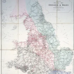
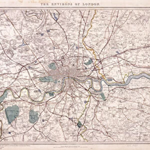
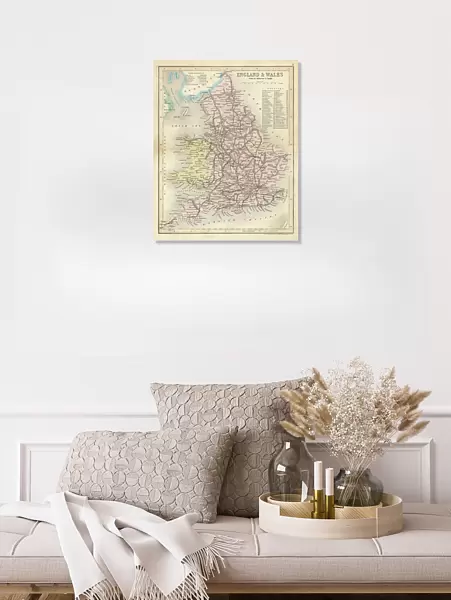
Canvas Print : Map / England & Wales 1857


![]()
Canvas Prints from Mary Evans Picture Library
Map / England & Wales 1857
Map of England and Wales showing railways and canals
Mary Evans Picture Library makes available wonderful images created for people to enjoy over the centuries
Media ID 608789
© Mary Evans Picture Library 2015 - https://copyrighthub.org/s0/hub1/creation/maryevans/MaryEvansPictureID/10113950
20"x16" (51x41cm) Canvas Print
Introducing the captivating "Map / England & Wales 1857" Canvas Print from the Media Storehouse collection, brought to you by Mary Evans Picture Library via Mary Evans Prints Online. This stunning piece of historical cartography transports you back in time, showcasing the intricate details of England and Wales' railways and canals in 1857. The rich, textured canvas material adds depth and dimension to the intricate lines and colors, making it a beautiful addition to any home or office. Travel back in time and adorn your walls with a piece of history that tells a story. Order your "Map / England & Wales 1857" Canvas Print today!
Delivered stretched and ready to hang our premium quality canvas prints are made from a polyester/cotton blend canvas and stretched over a 1.25" (32mm) kiln dried knot free wood stretcher bar. Packaged in a plastic bag and secured to a cardboard insert for safe transit.
Canvas Prints add colour, depth and texture to any space. Professionally Stretched Canvas over a hidden Wooden Box Frame and Ready to Hang
Estimated Product Size is 40.6cm x 50.8cm (16" x 20")
These are individually made so all sizes are approximate
Artwork printed orientated as per the preview above, with portrait (vertical) orientation to match the source image.
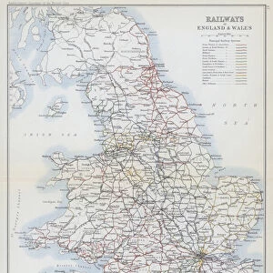
FEATURES IN THESE COLLECTIONS
> Europe
> United Kingdom
> England
> Maps
> Europe
> United Kingdom
> England
> Posters
> Europe
> United Kingdom
> England
> Railways
> Europe
> United Kingdom
> England
> Related Images
> Europe
> United Kingdom
> Wales
> Maps
> Europe
> United Kingdom
> Wales
> Posters
> Europe
> United Kingdom
> Wales
> Railways
> Europe
> United Kingdom
> Wales
> Related Images
> Maps and Charts
> Early Maps
> Maps and Charts
> Related Images
EDITORS COMMENTS
This stunning print of a map from 1857 showcases the intricate railway and canal systems of England and Wales during that time period. The detailed cartography provides a fascinating glimpse into the historical transportation networks that connected major cities and regions across Britain.
The map is not only a valuable resource for historians, but also serves as a beautiful piece of art with its intricate lines and labels depicting various towns, rivers, and landmarks throughout England and Wales. It captures an era when railways were rapidly expanding across the country, revolutionizing travel and trade in ways never seen before.
As we study this map, we can imagine the hustle and bustle of steam trains chugging along tracks, carrying passengers and goods to their destinations. We can envision the vital role that canals played in transporting goods between different regions, linking industrial centers with ports for international trade.
This print is not just a geographical representation; it is a window into the past that allows us to appreciate how far transportation technology has come since 1857. It reminds us of the importance of infrastructure in shaping societies and economies, making it a timeless piece that continues to captivate viewers today.
MADE IN THE USA
Safe Shipping with 30 Day Money Back Guarantee
FREE PERSONALISATION*
We are proud to offer a range of customisation features including Personalised Captions, Color Filters and Picture Zoom Tools
SECURE PAYMENTS
We happily accept a wide range of payment options so you can pay for the things you need in the way that is most convenient for you
* Options may vary by product and licensing agreement. Zoomed Pictures can be adjusted in the Cart.