Home > Europe > United Kingdom > England > London > Towns > Erith
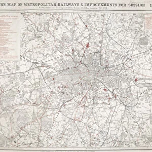
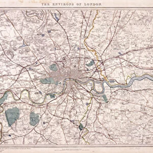
Map of London, c1860. Artist: Benjamin Rees Davies

![]()
Wall Art and Photo Gifts from Heritage Images
Map of London, c1860. Artist: Benjamin Rees Davies
Map of London and surrounding counties along the River Thames from Thames Ditton to Erith, with railway stations marked and the cemeteries coloured in grey
Heritage Images features heritage image collections
Media ID 15169826
© London Metropolitan Archives (City of London) / Heritage-Images
Cemetery Davies Essex Kent Railway Station Station Surrey Train Station
FEATURES IN THESE COLLECTIONS
> Arts
> Artists
> Related Images
> Arts
> Landscape paintings
> Waterfall and river artworks
> River artworks
> Europe
> United Kingdom
> England
> Essex
> Related Images
> Europe
> United Kingdom
> England
> Kent
> Ditton
> Europe
> United Kingdom
> England
> London
> Boroughs
> City of London
> Europe
> United Kingdom
> England
> London
> River Thames
> Europe
> United Kingdom
> England
> London
> Towns
> Erith
> Europe
> United Kingdom
> England
> London
> Transport
> Railway
> Europe
> United Kingdom
> England
> London
> Transport
> Stations
> Europe
> United Kingdom
> England
> Maps
EDITORS COMMENTS
This print showcases a remarkable "Map of London, c1860" created by the talented artist Benjamin Rees Davies. The map beautifully depicts the sprawling city of London and its surrounding counties along the majestic River Thames, stretching from Thames Ditton to Erith. What sets this map apart is that it not only highlights railway stations but also intriguingly colors the cemeteries in a somber shade of grey. Transportation enthusiasts will be thrilled to explore this intricate engraving as it meticulously marks out various railway stations across the region. Meanwhile, those with an interest in history and urban development can delve into the vibrant tapestry of 19th-century London life depicted on this extraordinary map. The inclusion of colored cemeteries adds a thought-provoking layer to this artwork. It serves as a poignant reminder of our mortality and invites contemplation on concepts such as death and burial practices during that era. This unique aspect makes Davies' creation even more compelling for art aficionados seeking deeper meaning within their visual experiences. Preserved at Guildhall Library and Art Gallery, this rare piece offers us an invaluable glimpse into Victorian England's transportation infrastructure while simultaneously capturing the essence of life in one of Europe's most iconic cities. Whether you are fascinated by maps or simply intrigued by historical artifacts, this exquisite print is sure to transport you back in time to witness London's past through Benjamin Rees Davies' skilled craftsmanship.
MADE IN THE USA
Safe Shipping with 30 Day Money Back Guarantee
FREE PERSONALISATION*
We are proud to offer a range of customisation features including Personalised Captions, Color Filters and Picture Zoom Tools
SECURE PAYMENTS
We happily accept a wide range of payment options so you can pay for the things you need in the way that is most convenient for you
* Options may vary by product and licensing agreement. Zoomed Pictures can be adjusted in the Cart.