Canvas Print > Granger Art on Demand > Maps
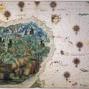
Canvas Print : MAP: AFRICA, ARABIA, INDIA. Map of North and East Africa, Arabia, and part of India


![]()
Canvas Prints from Granger
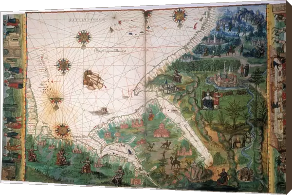
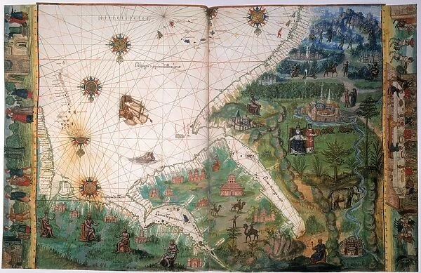
MAP: AFRICA, ARABIA, INDIA. Map of North and East Africa, Arabia, and part of India
MAP: AFRICA, ARABIA, INDIA.
Map of North and East Africa, Arabia, and part of India from the Vallard Atlas, c1547; the map, drawn upside-down as if viewed from Europe, depicts the legendary king of Abyssinia, Prester John
Granger holds millions of images spanning more than 25,000 years of world history, from before the Stone Age to the dawn of the Space Age
Media ID 12321010
1547 Arabia Arabian Asian Coastline Ethiopian India Portolan Chart Prester Topography Abyssinia
30"x20" (76x51cm) Canvas Print
Add a touch of history and geography to your home decor with our Canvas Prints featuring the intriguing map of "Africa, Arabia, India" by 140_1651645 from Granger Art on Demand. This captivating vintage map, originally from the Vallard Atlas of 1547, showcases North and East Africa, Arabia, and part of India. The map, drawn upside-down as if viewed from Europe, adds an interesting perspective to this historical piece. Showcasing intricate details and rich colors, our Canvas Prints are a perfect blend of art and education. Order yours today and bring a piece of the past into your living space.
Delivered stretched and ready to hang our premium quality canvas prints are made from a polyester/cotton blend canvas and stretched over a 1.25" (32mm) kiln dried knot free wood stretcher bar. Packaged in a plastic bag and secured to a cardboard insert for safe transit.
Canvas Prints add colour, depth and texture to any space. Professionally Stretched Canvas over a hidden Wooden Box Frame and Ready to Hang
Estimated Product Size is 76.2cm x 50.8cm (30" x 20")
These are individually made so all sizes are approximate
Artwork printed orientated as per the preview above, with landscape (horizontal) orientation to match the source image.
EDITORS COMMENTS
This print showcases a historical map titled "MAP: AFRICA, ARABIA, INDIA". Dating back to 1547 and sourced from the renowned Vallard Atlas, this map provides a unique perspective on North and East Africa, Arabia, and part of India. Interestingly, the cartographer chose to depict the map upside-down as if viewed from Europe. One notable feature of this ancient map is the depiction of the legendary king of Abyssinia known as Prester John. This mythical ruler adds an element of intrigue and mystery to an already fascinating piece. The intricate details captured in this print allow us to explore not only geographical aspects but also cultural connections between these regions during the Renaissance period. The visual representation includes significant landmarks such as coastlines, rivers, and topographical features that were crucial for navigation during that era. It offers a glimpse into how explorers perceived these territories centuries ago. As we delve into this historical artifact through Granger Art on Demand's lens, we are transported back in time when maps were hand-drawn with meticulous precision. This print serves as a reminder of our ever-evolving understanding of geography while honoring the craftsmanship behind ancient cartography.
MADE IN THE USA
Safe Shipping with 30 Day Money Back Guarantee
FREE PERSONALISATION*
We are proud to offer a range of customisation features including Personalised Captions, Color Filters and Picture Zoom Tools
SECURE PAYMENTS
We happily accept a wide range of payment options so you can pay for the things you need in the way that is most convenient for you
* Options may vary by product and licensing agreement. Zoomed Pictures can be adjusted in the Cart.