Canvas Print > Africa > Related Images
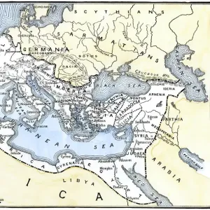
Canvas Print : Map of the reign of Alexandre the Great 1895


![]()
Canvas Prints From Fine Art Storehouse
Map of the reign of Alexandre the Great 1895
Meyers Konversations-Lexikon. Ein Nachschlagewerk des allgemeinen Wissens, 5th edition 17 volumes Bibliographisches Institut - Leipzig 1895-1897
Unleash your creativity and transform your space into a visual masterpiece!
THEPALMER
Media ID 13667325
© This content is subject to copyright
Alexander The Great Arabia Armenia Atlas Mythological Figure Cappadocia Egypt Ethiopia Horn Of Africa India Middle East Paper Persian Gulf Countries World Map
30"x20" (76x51cm) Canvas Print
Step back in time with our exquisite Canvas Print of the Map of the Reign of Alexandre the Great, 1895, by THEPALMER from our Media Storehouse Fine Art collection. This captivating map, originally published in the renowned Meyers Konversations-Lexikon, showcases the vast territories ruled by one of history's greatest conquerors. The intricate details and rich colors come alive on the textured canvas surface, making it a stunning addition to any room in your home or office. Embrace the historical significance and artistic beauty of this timeless piece.
Delivered stretched and ready to hang our premium quality canvas prints are made from a polyester/cotton blend canvas and stretched over a 1.25" (32mm) kiln dried knot free wood stretcher bar. Packaged in a plastic bag and secured to a cardboard insert for safe transit.
Canvas Prints add colour, depth and texture to any space. Professionally Stretched Canvas over a hidden Wooden Box Frame and Ready to Hang
Estimated Product Size is 76.2cm x 50.8cm (30" x 20")
These are individually made so all sizes are approximate
Artwork printed orientated as per the preview above, with landscape (horizontal) orientation to match the source image.
FEATURES IN THESE COLLECTIONS
> Africa
> Ethiopia
> Related Images
> Africa
> Related Images
> Asia
> Related Images
> Fine Art Storehouse
> Legends and Icons
> Famous Military Leaders
> Alexander the Great (356 bc-323 bc)
> Fine Art Storehouse
> Map
> Historical Maps
> Fine Art Storehouse
> Map
> USA Maps
EDITORS COMMENTS
This print takes us back in time to the year 1895, showcasing a beautifully detailed "Map of the reign of Alexandre the Great". Published in Meyers Konversations-Lexikon, this fifth edition atlas is a true testament to the wealth of knowledge held within its pages. The map itself spans horizontally, covering vast regions including Asia, the Middle East, India, Arabia, Egypt, Ethiopia, Armenia and even parts of the United States. Printed on old paper with an enchanting engraving style and intricate illustrations, this antique piece exudes historical charm. It offers a glimpse into ancient cartography and physical geography during Alexander the Great's era. As we explore this map further, we can trace his empire's reach from Cappadocia to Persian Gulf countries and all the way down to Horn of Africa. The craftsmanship displayed in this print is truly remarkable; every line tells a story and every detail invites curiosity. Whether you are an avid history enthusiast or simply appreciate fine artistry, this print will transport you through time as it adorns your space. Let yourself be captivated by its allure while embracing its rich historical significance - a true treasure for any collector or lover of world history.
MADE IN THE USA
Safe Shipping with 30 Day Money Back Guarantee
FREE PERSONALISATION*
We are proud to offer a range of customisation features including Personalised Captions, Color Filters and Picture Zoom Tools
SECURE PAYMENTS
We happily accept a wide range of payment options so you can pay for the things you need in the way that is most convenient for you
* Options may vary by product and licensing agreement. Zoomed Pictures can be adjusted in the Basket.