Canvas Print > North America > United States of America > Maps
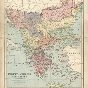
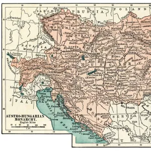
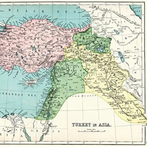
Canvas Print : Turkey Ottoman Empire map 1895


![]()
Canvas Prints from Fine Art Storehouse
Turkey Ottoman Empire map 1895
Meyers Konversations-Lexikon. Ein Nachschlagewerk des allgemeinen Wissens, 5th edition 17 volumes Bibliographisches Institut - Leipzig 1895-1897
Unleash your creativity and transform your space into a visual masterpiece!
THEPALMER
Media ID 13609313
© This content is subject to copyright
Empire Ottoman Turkey Turkey Middle East
20"x16" (51x41cm) Canvas Print
"Step back in time with our exquisite Canvas Print of the Turkey Ottoman Empire Map 1895 from ThePalmer's collection at Media Storehouse. This captivating piece, sourced from the esteemed Meyers Konversations-Lexikon, transports you to a bygone era with its intricate detail and historical significance. Perfectly rendered on premium canvas, this map is a stunning addition to any home or office, igniting curiosity and sparking conversation. Bring history to life with this beautiful and authentic work of art."
Delivered stretched and ready to hang our premium quality canvas prints are made from a polyester/cotton blend canvas and stretched over a 1.25" (32mm) kiln dried knot free wood stretcher bar. Packaged in a plastic bag and secured to a cardboard insert for safe transit.
Canvas Prints add colour, depth and texture to any space. Professionally Stretched Canvas over a hidden Wooden Box Frame and Ready to Hang
Estimated Product Size is 40.6cm x 50.8cm (16" x 20")
These are individually made so all sizes are approximate
Artwork printed orientated as per the preview above, with portrait (vertical) orientation to match the source image.
FEATURES IN THESE COLLECTIONS
> Asia
> Turkey
> Related Images
> Maps and Charts
> Related Images
> North America
> United States of America
> Maps
> Fine Art Storehouse
> Map
> Historical Maps
EDITORS COMMENTS
This print showcases a historical treasure, the "Turkey Ottoman Empire map 1895" sourced from Meyers Konversations-Lexikon. This remarkable piece of cartography takes us back to a bygone era, offering an intriguing glimpse into the vast and powerful Ottoman Empire. The map's intricate engravings and etchings are beautifully preserved, revealing the meticulous craftsmanship of its creators. With its vertical orientation, this antique illustration immerses us in a rich tapestry of physical geography, stretching across Turkey and the Middle East. As we explore this vintage masterpiece, we can't help but marvel at how it encapsulates both artistry and knowledge. The fine details depict cities, rivers, mountains, and borders with precision—a testament to the dedication that went into creating such comprehensive maps during that time. While admiring this print by THEPALMER from Fine Art Storehouse, one cannot overlook the significance of understanding history through visual representations like these. It serves as a reminder of how empires rise and fall while shaping our world today. Whether you're an enthusiast of old-world charm or someone fascinated by historical exploration, this stunning photograph print is sure to transport you back in time—offering endless opportunities for discovery within its carefully crafted lines and contours.
MADE IN THE USA
Safe Shipping with 30 Day Money Back Guarantee
FREE PERSONALISATION*
We are proud to offer a range of customisation features including Personalised Captions, Color Filters and Picture Zoom Tools
SECURE PAYMENTS
We happily accept a wide range of payment options so you can pay for the things you need in the way that is most convenient for you
* Options may vary by product and licensing agreement. Zoomed Pictures can be adjusted in the Cart.