Canvas Print > Fine Art Storehouse > Map
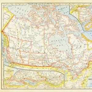
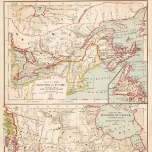
Canvas Print : Dominion of Canada map 1886


![]()
Canvas Prints from Fine Art Storehouse
Dominion of Canada map 1886
Dominion of Canada map Maps Monteith Physical Geography 1886
Unleash your creativity and transform your space into a visual masterpiece!
THEPALMER
Media ID 14756960
© This content is subject to copyright
20"x16" (51x41cm) Canvas Print
Step back in time with our stunning Dominion of Canada Map Canvas Print from Media Storehouse's Fine Art Storehouse collection. This beautiful piece, featuring the Dominion of Canada map from 1886 by THEPALMER (Monteith Physical Geography), transports you to a bygone era with its intricate details and vibrant colors. Perfect for history enthusiasts or those looking to add a touch of nostalgia to their decor, this high-quality canvas print is sure to make a statement in any room. Each print is carefully crafted using premium materials and printing techniques to ensure long-lasting beauty and vivid colors. Order yours today and let history come alive in your home!
Delivered stretched and ready to hang our premium quality canvas prints are made from a polyester/cotton blend canvas and stretched over a 1.25" (32mm) kiln dried knot free wood stretcher bar. Packaged in a plastic bag and secured to a cardboard insert for safe transit.
Canvas Prints add colour, depth and texture to any space. Professionally Stretched Canvas over a hidden Wooden Box Frame and Ready to Hang
Estimated Product Size is 50.8cm x 40.6cm (20" x 16")
These are individually made so all sizes are approximate
Artwork printed orientated as per the preview above, with landscape (horizontal) orientation to match the source image.
FEATURES IN THESE COLLECTIONS
> Fine Art Storehouse
> Map
> Historical Maps
EDITORS COMMENTS
In this print titled "Dominion of Canada map 1886" we are transported back in time to the late 19th century. The image showcases a meticulously detailed map, created by Monteith Physical Geography in the year 1886. This historical artifact offers us a glimpse into the vast Dominion of Canada during its early years. The intricate lines and delicate shading on the map highlight the immense geographical expanse that constituted Canada at that time. From coast to coast, we witness an array of provinces and territories coming together under one unified nation. It is fascinating to observe how boundaries have evolved since then, as well as marvel at the sheer size and diversity of this great land. "ThePALMER" has skillfully captured this antique piece with utmost precision, allowing us to appreciate every fine detail preserved within it. The monochrome palette adds a timeless quality to the photograph, enhancing our connection with history. This print from Fine Art Storehouse serves as more than just an aesthetic piece; it acts as a portal through which we can explore our past. Whether you are a history enthusiast or simply intrigued by cartography, this artwork will undoubtedly spark curiosity about Canada's rich heritage and its journey towards becoming the nation we know today.
MADE IN THE USA
Safe Shipping with 30 Day Money Back Guarantee
FREE PERSONALISATION*
We are proud to offer a range of customisation features including Personalised Captions, Color Filters and Picture Zoom Tools
SECURE PAYMENTS
We happily accept a wide range of payment options so you can pay for the things you need in the way that is most convenient for you
* Options may vary by product and licensing agreement. Zoomed Pictures can be adjusted in the Cart.