Home > North America > United States of America > New York > New York > Maps
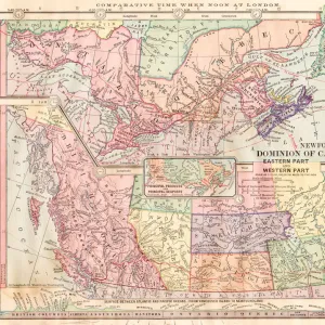
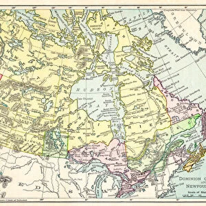
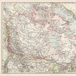
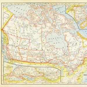
Map of the Canada dominion 1877

![]()
Wall Art and Photo Gifts from Fine Art Storehouse
Map of the Canada dominion 1877
The Eclectic Elementary Geography by Wilson & Hinkle / Cincinnati -New York 1881
Unleash your creativity and transform your space into a visual masterpiece!
THEPALMER
Media ID 18357129
FEATURES IN THESE COLLECTIONS
> Fine Art Storehouse
> Map
> Historical Maps
> Maps and Charts
> Early Maps
> North America
> Canada
> Maps
> North America
> United States of America
> New York
> New York
> Maps
EDITORS COMMENTS
In this print titled "Map of the Canada dominion 1877" we are transported back in time to an era when cartography was both a science and an art form. The map, originally published in "The Eclectic Elementary Geography" by Wilson & Hinkle in Cincinnati-New York, 1881, offers us a glimpse into the intricate details of Canada's dominion during that period. As our eyes wander across the surface of this vintage masterpiece, we are immediately struck by its exquisite craftsmanship. Every contour line, river system, and mountain range is meticulously drawn with precision and care. The delicate shading techniques employed by THEPALMER bring depth and dimension to each province and territory represented on the map. This particular rendition captures not only geographical accuracy but also historical significance. It serves as a testament to the growth and expansion of Canada during the late 19th century – a time when exploration and settlement were shaping the nation's identity. With its warm sepia tones evoking nostalgia for times gone by, this print from Fine Art Storehouse transports us back to an age where maps were cherished objects that sparked curiosity about distant lands. Whether displayed in a study or living room, it invites viewers to embark on their own imaginary journey through Canadian history while appreciating the sheer beauty of this timeless piece of artwork.
MADE IN THE USA
Safe Shipping with 30 Day Money Back Guarantee
FREE PERSONALISATION*
We are proud to offer a range of customisation features including Personalised Captions, Color Filters and Picture Zoom Tools
SECURE PAYMENTS
We happily accept a wide range of payment options so you can pay for the things you need in the way that is most convenient for you
* Options may vary by product and licensing agreement. Zoomed Pictures can be adjusted in the Cart.