Canvas Print > Fine Art Storehouse > Map
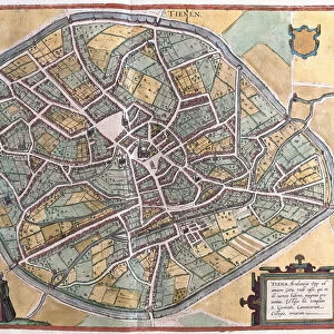
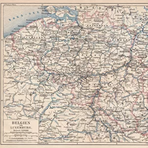
Canvas Print : City map of Antwerp and surrounding, Belgium, lithograph, published 1897


![]()
Canvas Prints from Fine Art Storehouse
City map of Antwerp and surrounding, Belgium, lithograph, published 1897
City map of Antwerp and surrounding, Belgium. Lithograph, published in 1897
Unleash your creativity and transform your space into a visual masterpiece!
Media ID 14646620
Antwerp Belgian Culture Belgium Benelux Canal City Map Colorful European Culture Flanders Haven Past Plan Port Surroundings Scheldt Scheldt River
30"x20" (76x51cm) Canvas Print
Step back in time with our exquisite Canvas Print of the City Map of Antwerp and Surrounding Areas, published in 1897. This stunning lithograph, part of our Media Storehouse Fine Art collection, transports you to the heart of Belgium's historic port city. The intricate details of the map, with its winding canals, bustling markets, and grand architecture, are brought to life in vibrant colors on a high-quality canvas. Hang this beautiful piece in your home or office to add a touch of timeless charm and historical depth to your decor. Perfect for map enthusiasts, history buffs, or anyone who appreciates the beauty of the past.
Delivered stretched and ready to hang our premium quality canvas prints are made from a polyester/cotton blend canvas and stretched over a 1.25" (32mm) kiln dried knot free wood stretcher bar. Packaged in a plastic bag and secured to a cardboard insert for safe transit.
Canvas Prints add colour, depth and texture to any space. Professionally Stretched Canvas over a hidden Wooden Box Frame and Ready to Hang
Estimated Product Size is 76.2cm x 50.8cm (30" x 20")
These are individually made so all sizes are approximate
Artwork printed orientated as per the preview above, with landscape (horizontal) orientation to match the source image.
FEATURES IN THESE COLLECTIONS
> Fine Art Storehouse
> Map
> Historical Maps
EDITORS COMMENTS
This vibrant lithograph print from 1897 showcases the intricate city map of Antwerp and its surrounding areas in Belgium. The detailed illustration captures the essence of this historic European city, known for its rich Belgian culture and captivating landscapes. The map highlights key features such as the meandering Scheldt River, which has played a significant role in shaping Antwerp's history and development. The bustling downtown district is depicted with colorful engravings, showcasing the architectural beauty that defines this charming town. As you explore this antique print, you can envision how Antwerp thrived as a prominent port city during the 19th century. Its strategic location along canals and its thriving harbor made it an essential hub for trade within Europe and beyond. This lithograph offers a glimpse into Antwerp's past, allowing us to appreciate both its historical significance and aesthetic charm. Whether you are an avid collector or simply fascinated by European culture, this stunning piece serves as a visual time capsule that transports you back to the late 19th century.
MADE IN THE USA
Safe Shipping with 30 Day Money Back Guarantee
FREE PERSONALISATION*
We are proud to offer a range of customisation features including Personalised Captions, Color Filters and Picture Zoom Tools
SECURE PAYMENTS
We happily accept a wide range of payment options so you can pay for the things you need in the way that is most convenient for you
* Options may vary by product and licensing agreement. Zoomed Pictures can be adjusted in the Cart.