Canvas Print > Europe > United Kingdom > England > London > Politics > John Major
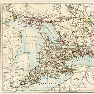
Canvas Print : Panorama of the Seat of War: Birds Eye View Of North And South Carolina And Part Of


![]()
Canvas Prints from Fine Art Finder
Panorama of the Seat of War: Birds Eye View Of North And South Carolina And Part Of
497534 Panorama of the Seat of War: Birds Eye View Of North And South Carolina And Part Of Georgia, 1861 (colour litho)
by Bachmann, John (fl.1850-77); 58x77 cm; Gilder Lehrman Collection, New York, USA; (add.info.: One of Bachmans six lithographic views of the Confederate States in the series: " Panorama of the Seat of War." Shows the Atlantic coast from Albemarle Sound south to Savannah and inland to the Blue Ridge Mountains. All the major towns of the Carolinas are located, as well as roads, railways, and sites of military interest. Confederate forts along the coast and the Union blockade appear in detail. A flotilla is pictured attacking forts at the entrance to Hatteras Inlet.
); eGilder Lehrman Institute of American History; American, out of copyright
Media ID 22918006
© Gilder Lehrman Institute of American History / Bridgeman Images
Aerial View American Civil War Birds Eye View Civil War Confederate Georgia North Carolina Panorama Seat Of War Secessionist South South Carolina Southern States Carolinas
20"x16" (51x41cm) Canvas Print
Experience the rich history of the American Civil War through the stunning visuals of our Media Storehouse Canvas Prints. This captivating panorama, titled "Birds Eye View Of North And South Carolina And Part Of Georgia," is an 1861 color lithograph by John Bachmann. Witness the intricate details of the landscape, showcasing the strategic locations of the Seat of War. Bring history into your home or office with this beautiful and authentic work of art from Fine Art Finder.
Delivered stretched and ready to hang our premium quality canvas prints are made from a polyester/cotton blend canvas and stretched over a 1.25" (32mm) kiln dried knot free wood stretcher bar. Packaged in a plastic bag and secured to a cardboard insert for safe transit.
Canvas Prints add colour, depth and texture to any space. Professionally Stretched Canvas over a hidden Wooden Box Frame and Ready to Hang
Estimated Product Size is 50.8cm x 40.6cm (20" x 16")
These are individually made so all sizes are approximate
Artwork printed orientated as per the preview above, with landscape (horizontal) orientation to match the source image.
FEATURES IN THESE COLLECTIONS
> Aerial Photography
> America
> Aerial Photography
> Georgia
> Aerial Photography
> Related Images
> Arts
> Artists
> B
> John Bird
> Asia
> Georgia
> Related Images
> Europe
> United Kingdom
> England
> London
> Politics
> John Major
> Maps and Charts
> Early Maps
> Fine Art Finder
> Artists
> Edouard Manet
> Fine Art Finder
> Artists
> John Bachmann
> Fine Art Finder
> Maps (celestial & Terrestrial)
EDITORS COMMENTS
This photo print, titled "Panorama of the Seat of War: Birds Eye View Of North And South Carolina And Part Of Georgia, 1861" offers a mesmerizing glimpse into the historical landscape of America during the Civil War. Created by John Bachmann, this color lithograph measures 58x77 cm and is part of the Gilder Lehrman Collection in New York. Bachmann's panoramic view showcases an expansive stretch along the Atlantic coast from Albemarle Sound to Savannah, with glimpses inland towards the Blue Ridge Mountains. With meticulous detail, he highlights major towns, roads, railways, and significant military sites throughout North and South Carolina. The Confederate forts dotting the coastline are showcased alongside Union blockades that played a crucial role in shaping this tumultuous period. Notably featured within this artwork is a dramatic depiction of a flotilla attacking forts at Hatteras Inlet—an intense moment frozen in time. This image serves as a powerful reminder of the conflict that unfolded between secessionist states during one of America's darkest chapters. Through its intricate portrayal of both land and sea elements, this panorama provides viewers with an immersive experience into Southern history. It captures not only key geographical features but also echoes sentiments from an era defined by division and struggle for control over these very lands. As we gaze upon this remarkable piece from American history, it invites us to reflect on our past while appreciating how far we have come as a nation united.
MADE IN THE USA
Safe Shipping with 30 Day Money Back Guarantee
FREE PERSONALISATION*
We are proud to offer a range of customisation features including Personalised Captions, Color Filters and Picture Zoom Tools
SECURE PAYMENTS
We happily accept a wide range of payment options so you can pay for the things you need in the way that is most convenient for you
* Options may vary by product and licensing agreement. Zoomed Pictures can be adjusted in the Cart.