Canvas Print > Europe > United Kingdom > England > Maps
Canvas Print : Map Showing The French Dominions Of Henry Ii. Illustrated Easy Stories From English History


![]()
Canvas Prints from Design Pics
Map Showing The French Dominions Of Henry Ii. Illustrated Easy Stories From English History
Design Pics offers Distinctively Different Imagery representing over 1,500 contributors
Media ID 18200336
© Ken Welsh / Design Pics
12th Cartography Dominions France Geographical Geography Henry Mapmaking Second Twelfth Possessions
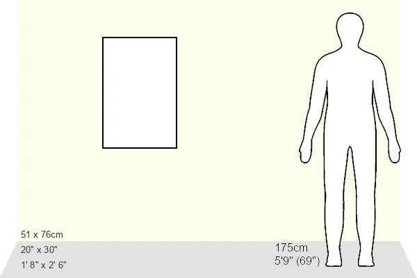
30"x20" (76x51cm) Canvas Print
Step back in time with our stunning Canvas Prints from Media Storehouse, featuring the captivating Map Showing The French Dominions Of Henry II by Ken Welsh from Design Pics. This exquisite illustration taken from "Easy Stories From English History" transports you to the medieval era of France, showcasing the vast territories ruled by King Henry II. The intricate details of the map are brought to life through our premium quality canvas material, providing a vibrant and textured finish that adds depth and character to any room. Hang this beautiful piece in your home or office as a conversation starter and a testament to historical artistry.
Delivered stretched and ready to hang our premium quality canvas prints are made from a polyester/cotton blend canvas and stretched over a 1.25" (32mm) kiln dried knot free wood stretcher bar. Packaged in a plastic bag and secured to a cardboard insert for safe transit.
Canvas Prints add colour, depth and texture to any space. Professionally Stretched Canvas over a hidden Wooden Box Frame and Ready to Hang
Estimated Product Size is 50.8cm x 76.2cm (20" x 30")
These are individually made so all sizes are approximate
Artwork printed orientated as per the preview above, with portrait (vertical) orientation to match the source image.
FEATURES IN THESE COLLECTIONS
> Europe
> United Kingdom
> England
> Maps
EDITORS COMMENTS
This print titled "Map Showing The French Dominions Of Henry II" takes us on a visual journey through the historical landscape of 12th-century France. Illustrated with intricate details, this map offers a glimpse into the vast dominions and possessions that belonged to King Henry II during his reign. The artistry in this piece is truly remarkable, as it showcases the skillful craftsmanship of cartography from centuries past. Every contour and boundary has been meticulously drawn, revealing the geographical intricacies of each region within France. As we delve deeper into this map, we are transported back in time to an era when kingdoms were expanding their territories and asserting their dominance. It serves as a reminder of the power struggles that shaped European history. While focusing primarily on France, this map also sheds light on England's connection to these French dominions during Henry II's rule. It highlights how intertwined these two countries were at that time and provides valuable insights into their shared history. Ken Welsh's expertise in capturing historical moments through photography is evident in this stunning print. With its rich colors and attention to detail, it not only serves as a beautiful decorative piece but also sparks curiosity about our past and encourages further exploration into English history.
MADE IN THE USA
Safe Shipping with 30 Day Money Back Guarantee
FREE PERSONALISATION*
We are proud to offer a range of customisation features including Personalised Captions, Color Filters and Picture Zoom Tools
SECURE PAYMENTS
We happily accept a wide range of payment options so you can pay for the things you need in the way that is most convenient for you
* Options may vary by product and licensing agreement. Zoomed Pictures can be adjusted in the Cart.