Home > Europe > United Kingdom > England > Maps
Jigsaw Puzzle : World Map / Overland India


![]()
Jigsaw Puzzles from Mary Evans Picture Library
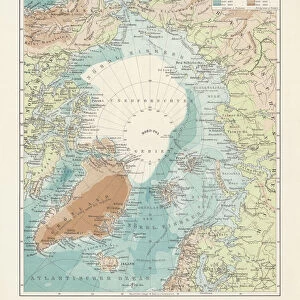
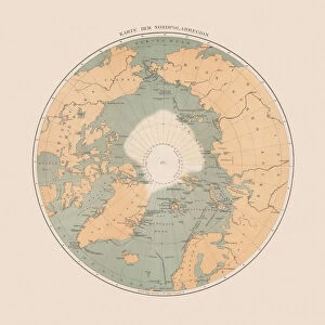
World Map / Overland India
The overland routes from England to India, compared with sea routes
Mary Evans Picture Library makes available wonderful images created for people to enjoy over the centuries
Media ID 4378969
© Mary Evans Picture Library 2015 - https://copyrighthub.org/s0/hub1/creation/maryevans/MaryEvansPictureID/10113709
Jigsaw Puzzle (252 Pieces)
Discover the rich history and cultural connections between Europe and India with our captivating jigsaw puzzle from the Media Storehouse collection. Featuring an intricately detailed World Map illustration by Rights Managed from Mary Evans Prints Online, this puzzle takes you on an adventure as you piece together the overland routes that once linked England to India. A fascinating educational activity for all ages, this puzzle not only challenges your problem-solving skills but also offers a unique perspective on historical trade and exploration. Immerse yourself in the journey and bring this beautiful map to life - one puzzle piece at a time.
Made in the USA, 252-piece puzzles measure 11" x 14" (27.9 x 35.5 cm). Every puzzle is meticulously printed on glossy photo paper, which has a strong 1.33 mm thickness. Delivered in a black storage cardboard box, these puzzles are both stylish and practical. (Note: puzzles contain small parts and are not suitable for children under 3 years of age.)
Jigsaw Puzzles are an ideal gift for any occasion
Estimated Product Size is 28cm x 35.6cm (11" x 14")
These are individually made so all sizes are approximate
Artwork printed orientated as per the preview above, with portrait (vertical) orientation to match the source image.
FEATURES IN THESE COLLECTIONS
> Asia
> India
> Related Images
> Europe
> France
> Canton
> Landes
> Europe
> United Kingdom
> England
> Maps
> Europe
> United Kingdom
> England
> Posters
> Europe
> United Kingdom
> England
> Related Images
> Maps and Charts
> Early Maps
> Maps and Charts
> India
> Maps and Charts
> Related Images
> Maps and Charts
> World
EDITORS COMMENTS
This print of a world map from the 1850s showcases the overland routes from England to India, providing a fascinating comparison with sea routes. The intricate details and historical significance of this map are truly remarkable, offering a glimpse into the past and how travel was conducted during that time period.
The map not only highlights the physical geography of both Europe and Asia but also sheds light on the various paths travelers would have taken to reach their destination. It serves as a visual representation of the extensive journey one would have embarked on in order to reach India from England, showcasing just how arduous and complex such a trip would have been.
With its vintage aesthetic and wealth of information, this print is sure to captivate history buffs and cartography enthusiasts alike. It provides a unique perspective on global transportation methods in the mid-19th century, offering valuable insights into how people navigated vast distances before modern technology made travel more accessible.
Overall, this stunning world map print is not just a decorative piece for your home or office – it's a window into an era when long-distance travel was an adventure filled with challenges and excitement. Explore the past through this beautifully detailed depiction of overland routes from England to India.
MADE IN THE USA
Safe Shipping with 30 Day Money Back Guarantee
FREE PERSONALISATION*
We are proud to offer a range of customisation features including Personalised Captions, Color Filters and Picture Zoom Tools
SECURE PAYMENTS
We happily accept a wide range of payment options so you can pay for the things you need in the way that is most convenient for you
* Options may vary by product and licensing agreement. Zoomed Pictures can be adjusted in the Cart.