Home > Maps and Charts > British Empire Maps
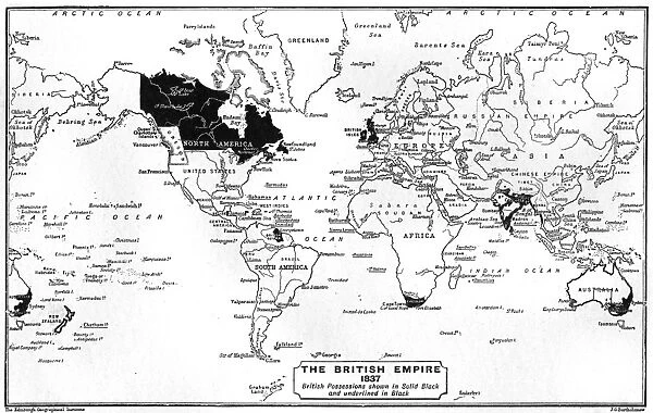
Canvas Print : WORLD MAP / 1837


![]()
Canvas Prints from Mary Evans Picture Library
WORLD MAP / 1837
Map of the world showing British Empire possessions Date: 1837
Mary Evans Picture Library makes available wonderful images created for people to enjoy over the centuries
Media ID 7132481
© Mary Evans Picture Library 2015 - https://copyrighthub.org/s0/hub1/creation/maryevans/MaryEvansPictureID/10039191
1837 Colonialism Maps Possessions
12"x9" (30x23cm) Canvas Print
"Travel back in time with our stunning Canvas Print of the "WORLD MAP / 1837" from Media Storehouse. This exquisite piece, sourced from Mary Evans Prints Online, showcases an intriguing map of the world as it was known in 1837. The map highlights the vast expanse of the British Empire at the time, offering a captivating glimpse into history. With its vibrant colors and high-quality canvas texture, this print adds an air of sophistication and intrigue to any room in your home or office. Perfect for history enthusiasts, world travelers, or those who appreciate the beauty of vintage maps, this Canvas Print from Media Storehouse is sure to become a cherished addition to your collection."
Delivered stretched and ready to hang our premium quality canvas prints are made from a polyester/cotton blend canvas and stretched over a 1.25" (32mm) kiln dried knot free wood stretcher bar. Packaged in a plastic bag and secured to a cardboard insert for safe transit.
Canvas Prints add colour, depth and texture to any space. Professionally Stretched Canvas over a hidden Wooden Box Frame and Ready to Hang
Estimated Product Size is 30.5cm x 22.9cm (12" x 9")
These are individually made so all sizes are approximate
Artwork printed orientated as per the preview above, with landscape (horizontal) orientation to match the source image.
FEATURES IN THESE COLLECTIONS
> Maps and Charts
> British Empire Maps
> Maps and Charts
> Related Images
> Maps and Charts
> World
MADE IN THE USA
Safe Shipping with 30 Day Money Back Guarantee
FREE PERSONALISATION*
We are proud to offer a range of customisation features including Personalised Captions, Color Filters and Picture Zoom Tools
SECURE PAYMENTS
We happily accept a wide range of payment options so you can pay for the things you need in the way that is most convenient for you
* Options may vary by product and licensing agreement. Zoomed Pictures can be adjusted in the Cart.