Home > Europe > France > Canton > Landes
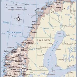
1865 Johnson Map Of Sweden Norway And Denmark

![]()
Wall Art and Photo Gifts from Universal Images Group (UIG)
1865 Johnson Map Of Sweden Norway And Denmark
1865, Johnson Map of Sweden, Norway and Denmark
Universal Images Group (UIG) manages distribution for many leading specialist agencies worldwide
Media ID 38549510
© Artokoloro Quint Lox Limited
1865 Antique Map Latitude Longitude Mappa Mundi Old Antique Plan Old Antique View Ols Antique Map Rare Old Maps Topo
FEATURES IN THESE COLLECTIONS
> Europe
> Denmark
> Related Images
> Europe
> France
> Canton
> Landes
> Europe
> Norway
> Related Images
> Europe
> Sweden
> Related Images
> Historic
> Space exploration
> Maps and Charts
> Early Maps
> Universal Images Group (UIG)
> History
> Historical Maps
EDITORS COMMENTS
Step back in time and explore the fascinating geography of Scandinavia with this stunning 1865 Johnson Map of Sweden, Norway, and Denmark. This vintage map is a treasure trove of cartographic history, offering a glimpse into the region's topography and cultural heritage.
The intricate details on this print reveal the countries' borders, cities, rivers, mountains, and forests with remarkable accuracy. The map also showcases the region's unique geographical features, such as fjords and islands. The illustration style is characteristic of its era, with ornate typography and decorative elements that add to its charm.
This historic map would make a beautiful addition to any room or office space. It's a conversation starter that will transport you back in time to an era when exploration was at its peak. Whether you're a history buff or simply appreciate vintage aesthetics, this print is sure to delight.
Hang it above your desk or sofa as a striking piece of art that celebrates human curiosity about our world. Let yourself be transported by the beauty of this 19th-century cartography masterpiece.
MADE IN THE USA
Safe Shipping with 30 Day Money Back Guarantee
FREE PERSONALISATION*
We are proud to offer a range of customisation features including Personalised Captions, Color Filters and Picture Zoom Tools
SECURE PAYMENTS
We happily accept a wide range of payment options so you can pay for the things you need in the way that is most convenient for you
* Options may vary by product and licensing agreement. Zoomed Pictures can be adjusted in the Cart.