Home > Europe > Italy > Veneto > Padua
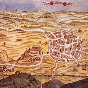
Plan of the city of Padua

![]()
Wall Art and Photo Gifts from Universal Images Group (UIG)
Plan of the city of Padua
Cartography, Italy, 15th century. Plan of the city of Padua
Universal Images Group (UIG) manages distribution for many leading specialist agencies worldwide
Media ID 9571559
© DEA / A. DE GREGORIO
15th Century City Fortified Wall Veneto Western Script Padova
FEATURES IN THESE COLLECTIONS
> Europe
> Italy
> Sculptures
> Europe
> Italy
> Veneto
> Padua
> Universal Images Group (UIG)
> Art
> Painting, Sculpture & Prints
> Cartography
EDITORS COMMENTS
This print showcases a remarkable piece of cartography, presenting the intricate "Plan of the city of Padua" from 15th century Italy. With its full length and horizontal composition, this studio shot allows us to delve into the rich history and physical geography of Padova. The artistry and craftsmanship evident in this illustration and painting are truly awe-inspiring. The map reveals a meticulously detailed depiction of Padua's urban landscape during an era long past. Every street, building, and fortified wall is intricately rendered with Western script labeling key landmarks. This historical artifact takes us on a visual journey back in time, offering glimpses into how the city was organized centuries ago. As we explore this ancient map, it becomes apparent that Padua was once a thriving center of culture and commerce within the Veneto region. Its strategic location along trade routes contributed to its prosperity throughout history. While devoid of people in this particular image, one can't help but imagine bustling crowds traversing these streets centuries ago—merchants haggling at market stalls or scholars engrossed in intellectual discussions at renowned universities. This print serves as a testament to human ingenuity and our enduring fascination with understanding our surroundings through cartography. It invites us to reflect upon how cities evolve over time while appreciating their roots firmly planted in the past.
MADE IN THE USA
Safe Shipping with 30 Day Money Back Guarantee
FREE PERSONALISATION*
We are proud to offer a range of customisation features including Personalised Captions, Color Filters and Picture Zoom Tools
SECURE PAYMENTS
We happily accept a wide range of payment options so you can pay for the things you need in the way that is most convenient for you
* Options may vary by product and licensing agreement. Zoomed Pictures can be adjusted in the Cart.