Home > Universal Images Group (UIG) > Art > Painting, Sculpture & Prints > Cartography
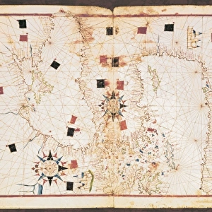
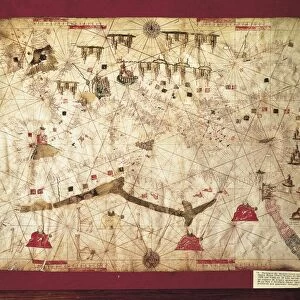
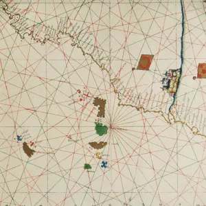
The Eastern Mediterranean, the Aegean Sea, Black Sea and a rose of 32 winds from a Portolan atlas in three charts, by John Xenodocos from Corfu, 1520

![]()
Wall Art and Photo Gifts from Universal Images Group (UIG)
The Eastern Mediterranean, the Aegean Sea, Black Sea and a rose of 32 winds from a Portolan atlas in three charts, by John Xenodocos from Corfu, 1520
Cartography, 16th century. The Eastern Mediterranean, the Aegean Sea, Black Sea and a rose of 32 winds. From a Portolan atlas in three charts, by John Xenodocos from Corfu, 1520, cm. 32 x 22.3
Universal Images Group (UIG) manages distribution for many leading specialist agencies worldwide
Media ID 9502147
© DEA / A. DAGLI ORTI
16th Century Black Sea Coastline Compass Rose Greece Mediterranean Sea Tent Turkey
EDITORS COMMENTS
This print showcases a rare gem from the 16th-century world of cartography. Created by John Xenodocos from Corfu in 1520, this Portolan atlas is a testament to the artistry and precision of ancient mapmaking. The image encompasses three charts that beautifully depict the Eastern Mediterranean, the Aegean Sea, and the Black Sea. Measuring at an impressive size of 32 x 22.3 cm, this antique piece transports us back in time to an era when exploration and navigation were paramount. The intricate details on display include a rose of 32 winds, serving as both a navigational tool and a work of art. The composition takes us on a visual journey through Europe, Asia, and Turkey with stunning accuracy. Each coastline is meticulously outlined while islands dotting the seas are delicately illustrated. This masterpiece captures not only geographical features but also evokes curiosity about historical trade routes and cultural exchanges that once thrived in these waters. As we gaze upon this remarkable artwork, it becomes evident that John Xenodocos possessed immense skill in his craft. His dedication to capturing every minute detail shines through each stroke on this vertical illustration. This print serves as more than just an artifact; it's an invitation to explore our past and appreciate the beauty inherent in ancient cartography—a true treasure for geography enthusiasts or anyone fascinated by history's enduring legacy.
MADE IN THE USA
Safe Shipping with 30 Day Money Back Guarantee
FREE PERSONALISATION*
We are proud to offer a range of customisation features including Personalised Captions, Color Filters and Picture Zoom Tools
SECURE PAYMENTS
We happily accept a wide range of payment options so you can pay for the things you need in the way that is most convenient for you
* Options may vary by product and licensing agreement. Zoomed Pictures can be adjusted in the Cart.