Premium Framed Print > Maps and Charts > Abraham Ortelius
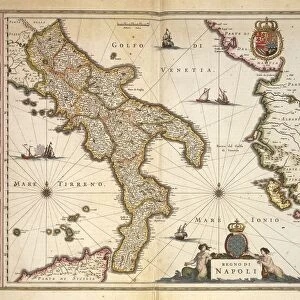
Premium Framed Print : Map of Italy from Theatrum Orbis Terrarum, by Abraham Ortelius, 1528-1598, engraving, 1570


![]()
Framed Photos From Universal Images Group (UIG)
Map of Italy from Theatrum Orbis Terrarum, by Abraham Ortelius, 1528-1598, engraving, 1570
Cartography, Italy, 16th century. Map of Italy, by Abraham Ortelius (1528-1598), from Theatrum Orbis Terrarum, 1570
Universal Images Group (UIG) manages distribution for many leading specialist agencies worldwide
Media ID 9502167
© DEA / G. DAGLI ORTI
1570 16th Century Aerial View Border Coastline Guidance Human Settlement Nautical Vessel Navigational Equipment Peninsula Sailing Ship Ship Text Transportation
14"x16" Premium Frame
Contemporary style Premium Wooden Frame with 8"x10" Print. Complete with 2" White Mat and 1.25" thick MDF frame. Printed on 260 gsm premium paper. Glazed with shatter proof UV coated acrylic glass. Backing is paper covered backing with rubber bumpers. Supplied ready to hang with a pre-installed sawtooth/wire hanger. Care Instructions: Spot clean with a damp cloth. Securely packaged in a clear plastic bag and envelope in a reinforced cardboard shipper
FSC Real Wood Frame and Double Mounted with White Conservation Mountboard - Professionally Made and Ready to Hang
Estimated Image Size (if not cropped) is 25.4cm x 20.3cm (10" x 8")
Estimated Product Size is 40.6cm x 35.6cm (16" x 14")
These are individually made so all sizes are approximate
Artwork printed orientated as per the preview above, with landscape (horizontal) orientation to match the source image.
EDITORS COMMENTS
This print showcases a remarkable piece of cartographic history - the Map of Italy from Theatrum Orbis Terrarum, created by Abraham Ortelius between 1528 and 1598. Engraved in 1570, this exquisite artwork provides us with a glimpse into the intricate world of 16th-century Italian topography. The map itself is an impressive display of craftsmanship, featuring detailed illustrations and text that guide viewers through the diverse landscapes and human settlements that dot the Italian peninsula. Its horizontal orientation allows for easy navigation, while its aerial view offers a unique perspective on Italy's coastline and surrounding seas. A sailing ship gracefully glides across these waters, symbolizing both transportation and exploration during this era. This image transports us back in time to an age when navigational equipment was still being developed, reminding us of the challenges faced by sailors as they ventured into uncharted territories. As we delve deeper into this artful engraving, it becomes evident that it is more than just a map; it is a testament to the rich history and cultural significance of Italy. Every stroke tells a story - stories of trade routes established along its borders, journeys embarked upon by intrepid explorers seeking new horizons, and centuries-old human settlements that have shaped this beautiful land. This print serves as an invaluable historical artifact, allowing us to appreciate not only the skillful artistry behind its creation but also providing insight into Italy's past. It invites us to embark on our own journey
MADE IN THE USA
Safe Shipping with 30 Day Money Back Guarantee
FREE PERSONALISATION*
We are proud to offer a range of customisation features including Personalised Captions, Color Filters and Picture Zoom Tools
SECURE PAYMENTS
We happily accept a wide range of payment options so you can pay for the things you need in the way that is most convenient for you
* Options may vary by product and licensing agreement. Zoomed Pictures can be adjusted in the Basket.