Premium Framed Print > Asia > Syria > Related Images
Premium Framed Print : GMDE2A-00055


![]()
Framed Photos From North Wind
GMDE2A-00055
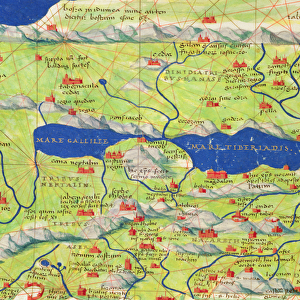
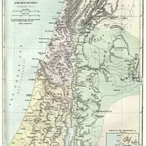
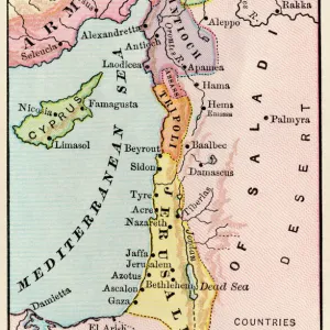
Map of northern Palestine in ancient times.
Printed color lithograph of a 19th-century illustration
North Wind Picture Archives brings history to life with stock images and hand-colored illustrations
Media ID 5882251
© North Wind Picture Archives
Ancient Civilization Biblical Galilee Lebanon Mediterranean Sea Mid East Middle East Palestine Phoenicia Sea Of Galilee Syria Territory Ancient World Jordan River Palestinian River Jordan
14"x18" Premium Frame
Contemporary style Premium Wooden Frame with 8"x12" Print. Complete with 2" White Mat and 1.25" thick MDF frame. Printed on 260 gsm premium paper. Glazed with shatter proof UV coated acrylic glass. Backing is paper covered backing with rubber bumpers. Supplied ready to hang with a pre-installed sawtooth/wire hanger. Care Instructions: Spot clean with a damp cloth. Securely packaged in a clear plastic bag and envelope in a reinforced cardboard shipper
FSC Real Wood Frame and Double Mounted with White Conservation Mountboard - Professionally Made and Ready to Hang
Estimated Image Size (if not cropped) is 20.3cm x 30.4cm (8" x 12")
Estimated Product Size is 35.6cm x 45.8cm (14" x 18")
These are individually made so all sizes are approximate
Artwork printed orientated as per the preview above, with portrait (vertical) orientation to match the source image.
FEATURES IN THESE COLLECTIONS
> North Wind Picture Archives
> Maps
> North Wind Picture Archives
> Mideast history
> Asia
> Syria
> Related Images
EDITORS COMMENTS
This photo print, titled "GMDE2A-00055 (Map of northern Palestine in ancient times)" takes us on a journey back to the rich history of the Middle East. The image showcases a printed color lithograph of a 19th-century illustration, exuding vintage charm and traditional artistry. The map itself is an intricate depiction of ancient civilization, offering insights into biblical times and shedding light on the historic territory that once encompassed northern Palestine. Stretching from Syria to Lebanon, this region includes significant landmarks such as Galilee, Phoenicia, and the River Jordan. As we explore this mesmerizing artwork, our eyes are drawn to the vivid colors that bring life to each detail. The Mediterranean Sea glistens with its azure hues while the Sea of Galilee shimmers nearby. The Jordan River meanders through the landscape like a lifeline connecting these ancient lands. This piece serves as a visual gateway into an era long gone but not forgotten. It invites us to delve deeper into Palestinian history and appreciate its cultural significance within the broader context of the Middle East's ancient world. With its blend of artistic mastery and historical relevance, this print stands as both an exquisite work of art and an educational tool for those curious about our shared past. Whether displayed in homes or institutions dedicated to preserving heritage, it sparks conversations about civilizations that have shaped our present-day world.
MADE IN THE USA
Safe Shipping with 30 Day Money Back Guarantee
FREE PERSONALISATION*
We are proud to offer a range of customisation features including Personalised Captions, Color Filters and Picture Zoom Tools
SECURE PAYMENTS
We happily accept a wide range of payment options so you can pay for the things you need in the way that is most convenient for you
* Options may vary by product and licensing agreement. Zoomed Pictures can be adjusted in the Basket.