Premium Framed Print > Arts > Artists > O > Oceanic Oceanic
Premium Framed Print : Newfoundland, 1870s


![]()
Framed Photos From North Wind
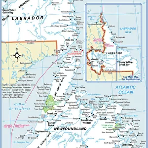
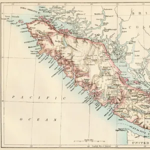
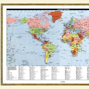
Newfoundland, 1870s
Map of Newfoundland, Canada, 1870s.
Printed color lithograph
North Wind Picture Archives brings history to life with stock images and hand-colored illustrations
Media ID 5879751
© North Wind Picture Archives
1870s Atlantic Coast Atlantic Ocean Canada Canadian Island Maritime Provinces Newfoundland Maritimes
14"x16" Premium Frame
Contemporary style Premium Wooden Frame with 8"x10" Print. Complete with 2" White Mat and 1.25" thick MDF frame. Printed on 260 gsm premium paper. Glazed with shatter proof UV coated acrylic glass. Backing is paper covered backing with rubber bumpers. Supplied ready to hang with a pre-installed sawtooth/wire hanger. Care Instructions: Spot clean with a damp cloth. Securely packaged in a clear plastic bag and envelope in a reinforced cardboard shipper
FSC Real Wood Frame and Double Mounted with White Conservation Mountboard - Professionally Made and Ready to Hang
Estimated Image Size (if not cropped) is 20.3cm x 25.4cm (8" x 10")
Estimated Product Size is 35.6cm x 40.6cm (14" x 16")
These are individually made so all sizes are approximate
Artwork printed orientated as per the preview above, with portrait (vertical) orientation to match the source image.
FEATURES IN THESE COLLECTIONS
> North Wind Picture Archives
> Canadian history
> North Wind Picture Archives
> Maps
> Arts
> Artists
> O
> Oceanic Oceanic
> Maps and Charts
> Popular Maps
> Maps and Charts
> Related Images
> North America
> Canada
> Maps
> North America
> Canada
> Related Images
> Popular Themes
> North Island
EDITORS COMMENTS
This vintage print takes us back to the 1870s, offering a glimpse into the rich history and heritage of Newfoundland, Canada. The beautifully detailed map showcases this island's unique position in the Atlantic Ocean, nestled off the eastern coast of North America. With its vibrant printed colors and intricate lithograph technique, this artwork captures the essence of a bygone era. As we explore this historic illustration, we are transported to a time when Newfoundland was still an independent colony. The map highlights not only its geographical features but also provides insight into its maritime provinces and their significance within Canadian history. It serves as a reminder of how vital these coastal regions were for trade and exploration during that period. The artistry displayed in this print is truly remarkable; it evokes feelings of nostalgia while celebrating the natural beauty and cultural importance of Newfoundland. This piece offers viewers an opportunity to appreciate both the artistic talent involved in creating such maps during the 19th century and gain knowledge about historical events that shaped this region. Whether you have personal ties to Newfoundland or simply appreciate fine art with historical significance, this vintage print is sure to be treasured for years to come. Its presence on any wall will serve as a testament to our shared past and remind us of the enduring allure found within our world's diverse landscapes.
MADE IN THE USA
Safe Shipping with 30 Day Money Back Guarantee
FREE PERSONALISATION*
We are proud to offer a range of customisation features including Personalised Captions, Color Filters and Picture Zoom Tools
SECURE PAYMENTS
We happily accept a wide range of payment options so you can pay for the things you need in the way that is most convenient for you
* Options may vary by product and licensing agreement. Zoomed Pictures can be adjusted in the Basket.