Premium Framed Print > Europe > United Kingdom > England > Maps
Premium Framed Print : London Map 1560 / Aggas


![]()
Framed Photos from Mary Evans Picture Library
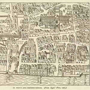
London Map 1560 / Aggas
Map of London at the time of Queen Elizabeth I
Mary Evans Picture Library makes available wonderful images created for people to enjoy over the centuries
Media ID 594343
© Mary Evans Picture Library 2015 - https://copyrighthub.org/s0/hub1/creation/maryevans/MaryEvansPictureID/10046440
16"x16" Premium Frame
Contemporary style Premium Wooden Frame with 10"x10" Print. Complete with 2" White Mat and 1.25" thick MDF frame. Printed on 260 gsm premium paper. Glazed with shatter proof UV coated acrylic glass. Backing is paper covered backing with rubber bumpers. Supplied ready to hang with a pre-installed sawtooth/wire hanger. Care Instructions: Spot clean with a damp cloth. Securely packaged in a clear plastic bag and envelope in a reinforced cardboard shipper
FSC Real Wood Frame and Double Mounted with White Conservation Mountboard - Professionally Made and Ready to Hang
Estimated Image Size (if not cropped) is 25.4cm x 25.4cm (10" x 10")
Estimated Product Size is 40.6cm x 40.6cm (16" x 16")
These are individually made so all sizes are approximate
Artwork printed orientated as per the preview above, with landscape (horizontal) or portrait (vertical) orientation to match the source image.
FEATURES IN THESE COLLECTIONS
> Mary Evans Prints Online
> Maps
> Europe
> United Kingdom
> England
> London
> Related Images
> Europe
> United Kingdom
> England
> Maps
> Europe
> United Kingdom
> England
> Posters
> Europe
> United Kingdom
> England
> Related Images
> Maps and Charts
> Early Maps
> Maps and Charts
> Related Images
EDITORS COMMENTS
This stunning print captures a piece of history with the "London Map 1560 / Aggas" showcasing the city at the time of Queen Elizabeth I. The intricate details and craftsmanship of this map provide a glimpse into what London looked like during this significant period in English history.
As you study the map, you can see how different landmarks were laid out back in 1560, giving insight into how people navigated through the bustling streets and neighborhoods of London. The attention to detail is truly remarkable, from the winding river Thames to the various buildings and structures that dotted the landscape.
Queen Elizabeth I's reign was known for its prosperity and cultural flourishing, making this map even more fascinating as it offers a visual representation of her time on the throne. It serves as a reminder of England's rich heritage and royal lineage that continues to captivate historians and enthusiasts alike.
Whether you're a history buff or simply appreciate fine artistry, this print is sure to spark curiosity and admiration for London's past. Displaying it in your home or office will not only add a touch of elegance but also serve as a conversation starter about one of the most iconic cities in the world.
MADE IN THE USA
Safe Shipping with 30 Day Money Back Guarantee
FREE PERSONALISATION*
We are proud to offer a range of customisation features including Personalised Captions, Color Filters and Picture Zoom Tools
SECURE PAYMENTS
We happily accept a wide range of payment options so you can pay for the things you need in the way that is most convenient for you
* Options may vary by product and licensing agreement. Zoomed Pictures can be adjusted in the Cart.