Premium Framed Print > Maps and Charts > Early Maps
Premium Framed Print : Map of Gibraltar (XVIIIIth c. ). Etching
. Etching")
. Etching")


![]()
Framed Photos From Mary Evans Picture Library
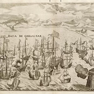
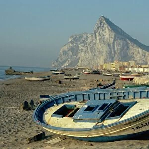
Map of Gibraltar (XVIIIIth c. ). Etching
Map of Gibraltar (XVIIIIth c.). Etching
Mary Evans Picture Library makes available wonderful images created for people to enjoy over the centuries
Media ID 8273425
© Mary Evans Picture Library 2015 - https://copyrighthub.org/s0/hub1/creation/maryevans/MaryEvansPictureID/10687011
Engravings Etching Etchings Geographic Geographical Geography Gibraltar Technical Technician Technicians Technique Techniques Technological Technology Transportations Transports
14"x16" Premium Frame
Contemporary style Premium Wooden Frame with 8"x10" Print. Complete with 2" White Mat and 1.25" thick MDF frame. Printed on 260 gsm premium paper. Glazed with shatter proof UV coated acrylic glass. Backing is paper covered backing with rubber bumpers. Supplied ready to hang with a pre-installed sawtooth/wire hanger. Care Instructions: Spot clean with a damp cloth. Securely packaged in a clear plastic bag and envelope in a reinforced cardboard shipper
FSC Real Wood Frame and Double Mounted with White Conservation Mountboard - Professionally Made and Ready to Hang
Estimated Image Size (if not cropped) is 25.4cm x 20.3cm (10" x 8")
Estimated Product Size is 40.6cm x 35.6cm (16" x 14")
These are individually made so all sizes are approximate
Artwork printed orientated as per the preview above, with landscape (horizontal) orientation to match the source image.
FEATURES IN THESE COLLECTIONS
> Maps and Charts
> Early Maps
> Maps and Charts
> Related Images
EDITORS COMMENTS
This stunning print captures a historical map of Gibraltar from the XVIIth century, showcasing intricate details and vibrant colors. The etching technique used to create this map highlights the skilled craftsmanship and technical expertise of the artist.
The geographical accuracy of this map is impressive, providing a glimpse into the transportation routes and landmarks of Gibraltar during this time period. The historical significance of this piece is evident in its depiction of a bygone era, offering viewers a window into the past.
The horizontal layout of the map allows for easy navigation and study, making it an invaluable resource for historians and enthusiasts alike. The use of color adds depth and dimension to the etching, bringing each detail to life with precision.
Overall, this print serves as a testament to both the technological advancements of its time and the artistic talent required to produce such intricate engravings. It stands as a reminder of Gibraltar's rich history and cultural heritage, preserved through meticulous craftsmanship and attention to detail.
Whether displayed in a home or office setting, this Map of Gibraltar (XVIIth c.) Etching is sure to captivate viewers with its beauty and historical significance.
MADE IN THE USA
Safe Shipping with 30 Day Money Back Guarantee
FREE PERSONALISATION*
We are proud to offer a range of customisation features including Personalised Captions, Color Filters and Picture Zoom Tools
SECURE PAYMENTS
We happily accept a wide range of payment options so you can pay for the things you need in the way that is most convenient for you
* Options may vary by product and licensing agreement. Zoomed Pictures can be adjusted in the Basket.