Premium Framed Print : Map / Asia / Tibet Etc 1845


![]()
Framed Photos from Mary Evans Picture Library
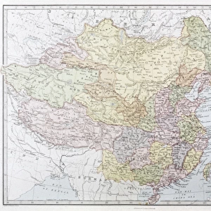
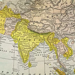
Map / Asia / Tibet Etc 1845
Map of Tibet, Mongolia and Manchuria
Mary Evans Picture Library makes available wonderful images created for people to enjoy over the centuries
Media ID 608839
© Mary Evans Picture Library 2015 - https://copyrighthub.org/s0/hub1/creation/maryevans/MaryEvansPictureID/10114140
1845 Manchuria Maps Mongolia Tibet
14"x16" Premium Frame
Contemporary style Premium Wooden Frame with 8"x10" Print. Complete with 2" White Mat and 1.25" thick MDF frame. Printed on 260 gsm premium paper. Glazed with shatter proof UV coated acrylic glass. Backing is paper covered backing with rubber bumpers. Supplied ready to hang with a pre-installed sawtooth/wire hanger. Care Instructions: Spot clean with a damp cloth. Securely packaged in a clear plastic bag and envelope in a reinforced cardboard shipper
FSC Real Wood Frame and Double Mounted with White Conservation Mountboard - Professionally Made and Ready to Hang
Estimated Image Size (if not cropped) is 25.4cm x 20.3cm (10" x 8")
Estimated Product Size is 40.6cm x 35.6cm (16" x 14")
These are individually made so all sizes are approximate
Artwork printed orientated as per the preview above, with landscape (horizontal) orientation to match the source image.
EDITORS COMMENTS
This stunning historical print from Mary Evans Picture Library takes us back to the year 1845, showcasing a detailed map of Tibet, Mongolia, and Manchuria in Asia. The intricate details on the map provide a glimpse into the geography and boundaries of these regions during that time period.
The map not only serves as a valuable historical document but also offers insight into the political landscape of Asia in the mid-19th century. It highlights the vast expanse of Tibet, with its mountainous terrain and remote location, as well as the neighboring regions of Mongolia and Manchuria.
As we study this fascinating piece of cartography, we are transported to a different era when exploration and discovery were at the forefront of human endeavor. The meticulous craftsmanship evident in every line and symbol on the map is a testament to the skill and dedication of those who created it.
Whether you have an interest in history, geography, or simply appreciate fine artistry, this print is sure to captivate your imagination. It serves as a reminder of how maps have played a crucial role in shaping our understanding of the world around us. Take a closer look at this Map / Asia / Tibet Etc 1845 print from Mary Evans Prints Online and embark on a journey through time and space.
MADE IN THE USA
Safe Shipping with 30 Day Money Back Guarantee
FREE PERSONALISATION*
We are proud to offer a range of customisation features including Personalised Captions, Color Filters and Picture Zoom Tools
SECURE PAYMENTS
We happily accept a wide range of payment options so you can pay for the things you need in the way that is most convenient for you
* Options may vary by product and licensing agreement. Zoomed Pictures can be adjusted in the Cart.