Premium Framed Print > Animals > Mammals > Didelphidae > Formosa
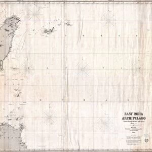
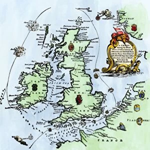
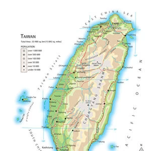
Premium Framed Print : 1863, Cassells Dispatch Atlas Map of Taiwan, Formosa and the Hainan Coast of China


![]()
Framed Photos From Liszt Collection
1863, Cassells Dispatch Atlas Map of Taiwan, Formosa and the Hainan Coast of China
Liszt Collection of nineteenth-century engravings and images to browse and enjoy
Media ID 14005978
© Artokoloro Quint Lox Limited
1863 Antique Map Latitude Longitude Mappa Mundi Old Antique Plan Old Antique View Ols Antique Map Rare Old Maps Topo
14"x16" Premium Frame
Contemporary style Premium Wooden Frame with 8"x10" Print. Complete with 2" White Mat and 1.25" thick MDF frame. Printed on 260 gsm premium paper. Glazed with shatter proof UV coated acrylic glass. Backing is paper covered backing with rubber bumpers. Supplied ready to hang with a pre-installed sawtooth/wire hanger. Care Instructions: Spot clean with a damp cloth. Securely packaged in a clear plastic bag and envelope in a reinforced cardboard shipper
FSC Real Wood Frame and Double Mounted with White Conservation Mountboard - Professionally Made and Ready to Hang
Estimated Image Size (if not cropped) is 20.3cm x 25.4cm (8" x 10")
Estimated Product Size is 35.6cm x 40.6cm (14" x 16")
These are individually made so all sizes are approximate
Artwork printed orientated as per the preview above, with portrait (vertical) orientation to match the source image.
FEATURES IN THESE COLLECTIONS
> Animals
> Mammals
> Didelphidae
> Formosa
> Asia
> Taiwan
> Related Images
> Europe
> France
> Canton
> Landes
> Historic
> Space exploration
> Maps and Charts
> Early Maps
> Maps and Charts
> Related Images
> Maps and Charts
> World
EDITORS COMMENTS
This print showcases the remarkable "1863, Cassells Dispatch Atlas Map of Taiwan, Formosa and the Hainan Coast of China". A true treasure for history enthusiasts, this vintage map offers a glimpse into the past with its intricate topography and detailed cartography. The artist's skillful illustration brings to life the geographic features of this region, allowing viewers to embark on a visual journey through time. The map's grid system accurately depicts latitude and longitude lines, adding a touch of geometric precision to its overall design. Its aged appearance adds an air of authenticity and charm, making it a perfect decorative piece for any space. This old-world artifact serves as an invaluable tool for navigation and exploration during its era. As we gaze upon this rare antique map from the Liszt Collection, we are transported back in time to witness how our world was perceived over a century ago. It reminds us of the rich history that has shaped our planet throughout centuries of discovery and geographical understanding.
MADE IN THE USA
Safe Shipping with 30 Day Money Back Guarantee
FREE PERSONALISATION*
We are proud to offer a range of customisation features including Personalised Captions, Color Filters and Picture Zoom Tools
SECURE PAYMENTS
We happily accept a wide range of payment options so you can pay for the things you need in the way that is most convenient for you
* Options may vary by product and licensing agreement. Zoomed Pictures can be adjusted in the Basket.