Premium Framed Print > Europe > United Kingdom > England > Related Images
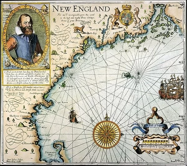
Premium Framed Print : NEW ENGLAND: MAP. John Smiths map of New England, 1616
![]()

Framed Photos From Granger
NEW ENGLAND: MAP. John Smiths map of New England, 1616
Granger holds millions of images spanning more than 25,000 years of world history, from before the Stone Age to the dawn of the Space Age
Media ID 6620029
1616 Captain Colonist Colony New England Portolan Chart Settlement Settler Smith
14"x16" Premium Frame
Contemporary style Premium Wooden Frame with 8"x10" Print. Complete with 2" White Mat and 1.25" thick MDF frame. Printed on 260 gsm premium paper. Glazed with shatter proof UV coated acrylic glass. Backing is paper covered backing with rubber bumpers. Supplied ready to hang with a pre-installed sawtooth/wire hanger. Care Instructions: Spot clean with a damp cloth. Securely packaged in a clear plastic bag and envelope in a reinforced cardboard shipper
FSC Real Wood Frame and Double Mounted with White Conservation Mountboard - Professionally Made and Ready to Hang
Estimated Image Size (if not cropped) is 25.4cm x 20.3cm (10" x 8")
Estimated Product Size is 40.6cm x 35.6cm (16" x 14")
These are individually made so all sizes are approximate
Artwork printed orientated as per the preview above, with landscape (horizontal) orientation to match the source image.
FEATURES IN THESE COLLECTIONS
> Granger Art on Demand
> Maps
> Europe
> United Kingdom
> England
> Related Images
EDITORS COMMENTS
In this print titled "NEW ENGLAND: MAP" we are transported back in time to the year 1616, when Captain John Smith's map of New England was created. This historical artifact serves as a testament to the early days of American exploration and settlement. As we gaze upon this intricate map, we can envision the brave colonists who embarked on a perilous journey across vast oceans, seeking new opportunities and freedom in an untamed land. Smith's meticulous cartography skillfully depicts the rivers, coastlines, and settlements that would eventually become iconic landmarks in New England's history. The map not only showcases the geographical features of the region but also provides insight into the mindset of those early settlers. It represents their determination to establish thriving colonies amidst unfamiliar terrain and harsh conditions. Through this artwork by The Granger Collection, we gain a glimpse into an era where portolan charts were essential tools for navigation and exploration. The attention to detail exhibited in Smith's map reflects his dedication to accurately documenting his discoveries. This print is not just a visual representation; it is a window into our past—a reminder of those courageous individuals who laid down roots in what would become one of America's most significant regions. It invites us to appreciate their pioneering spirit while acknowledging how their efforts shaped New England's rich cultural heritage that endures today.
MADE IN THE USA
Safe Shipping with 30 Day Money Back Guarantee
FREE PERSONALISATION*
We are proud to offer a range of customisation features including Personalised Captions, Color Filters and Picture Zoom Tools
SECURE PAYMENTS
We happily accept a wide range of payment options so you can pay for the things you need in the way that is most convenient for you
* Options may vary by product and licensing agreement. Zoomed Pictures can be adjusted in the Basket.


