Premium Framed Print > Arts > Artists > P > Polynesian Polynesian
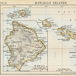
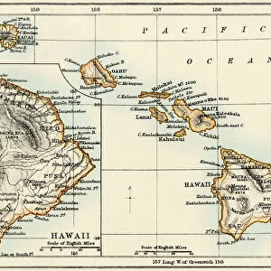
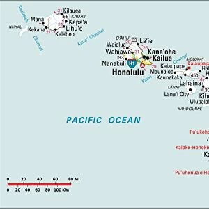
Premium Framed Print : MAP: HAWAII, 1905. Map of the Hawaiian Islands printed in the United States in 1905


![]()
Framed Photos from Granger
MAP: HAWAII, 1905. Map of the Hawaiian Islands printed in the United States in 1905
Granger holds millions of images spanning more than 25,000 years of world history, from before the Stone Age to the dawn of the Space Age
Media ID 6620087
1905 Hawaii Island Pacific Ocean Polynesia Polynesian
14"x16" Premium Frame
Contemporary style Premium Wooden Frame with 8"x10" Print. Complete with 2" White Mat and 1.25" thick MDF frame. Printed on 260 gsm premium paper. Glazed with shatter proof UV coated acrylic glass. Backing is paper covered backing with rubber bumpers. Supplied ready to hang with a pre-installed sawtooth/wire hanger. Care Instructions: Spot clean with a damp cloth. Securely packaged in a clear plastic bag and envelope in a reinforced cardboard shipper
FSC Real Wood Frame and Double Mounted with White Conservation Mountboard - Professionally Made and Ready to Hang
Estimated Image Size (if not cropped) is 25.4cm x 20.3cm (10" x 8")
Estimated Product Size is 40.6cm x 35.6cm (16" x 14")
These are individually made so all sizes are approximate
Artwork printed orientated as per the preview above, with landscape (horizontal) orientation to match the source image.
FEATURES IN THESE COLLECTIONS
> Granger Art on Demand
> Maps
> Arts
> Artists
> O
> Oceanic Oceanic
> Arts
> Artists
> P
> Polynesian Polynesian
> Arts
> Landscape paintings
> Waterfall and river artworks
> River artworks
> Maps and Charts
> Early Maps
> Maps and Charts
> Related Images
EDITORS COMMENTS
This print takes us back in time to the year 1905, showcasing a meticulously detailed map of the enchanting Hawaiian Islands. Created and printed in the United States, this vintage piece offers a glimpse into an era when cartography was both an art form and a scientific endeavor. The map itself is a testament to the skill and precision of its creators, capturing every intricate detail of Hawaii's diverse topography. From lush mountains to winding rivers, it paints a vivid picture of this Polynesian paradise nestled in the vast expanse of the Pacific Ocean. As we explore this historical artifact, we are transported to an early period where Hawaii's rich cultural heritage thrived. The islands' indigenous Polynesian roots are beautifully represented through their names and landmarks on the map – reminding us that these lands have been cherished by generations long before Western influence arrived. With its vibrant colors and fine craftsmanship, this Granger Collection print captures not only geographical accuracy but also serves as a visual tribute to Hawaii's unique allure. It invites viewers to embark on an imaginary journey through time, immersing themselves in the natural beauty that has made these islands so beloved throughout history. Whether you're an avid traveler or simply fascinated by history, this remarkable image allows you to admire Hawaii from afar while appreciating how far cartography has come since its creation over a century ago.
MADE IN THE USA
Safe Shipping with 30 Day Money Back Guarantee
FREE PERSONALISATION*
We are proud to offer a range of customisation features including Personalised Captions, Color Filters and Picture Zoom Tools
SECURE PAYMENTS
We happily accept a wide range of payment options so you can pay for the things you need in the way that is most convenient for you
* Options may vary by product and licensing agreement. Zoomed Pictures can be adjusted in the Cart.