Premium Framed Print > Arts > Still life artwork > Watercolor paintings > Fine art
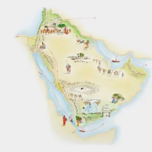
Premium Framed Print : Illustrated map of ancient Arab trade routes and pilgrimage sites


![]()
Framed Photos from Fine Art Storehouse
Illustrated map of ancient Arab trade routes and pilgrimage sites
Unleash your creativity and transform your space into a visual masterpiece!
Dorling Kindersley
Media ID 13540743
© This content is subject to copyright
Arabian Peninsula Background People Business Camel Train Commerce Geography Illustrated Map Incidental People Saudi Arabia Trading Mecca Watercolour Painting
14"x16" Premium Frame
Contemporary style Premium Wooden Frame with 8"x10" Print. Complete with 2" White Mat and 1.25" thick MDF frame. Printed on 260 gsm premium paper. Glazed with shatter proof UV coated acrylic glass. Backing is paper covered backing with rubber bumpers. Supplied ready to hang with a pre-installed sawtooth/wire hanger. Care Instructions: Spot clean with a damp cloth. Securely packaged in a clear plastic bag and envelope in a reinforced cardboard shipper
FSC Real Wood Frame and Double Mounted with White Conservation Mountboard - Professionally Made and Ready to Hang
Estimated Image Size (if not cropped) is 25.4cm x 20.3cm (10" x 8")
Estimated Product Size is 40.6cm x 35.6cm (16" x 14")
These are individually made so all sizes are approximate
Artwork printed orientated as per the preview above, with landscape (horizontal) orientation to match the source image.
FEATURES IN THESE COLLECTIONS
> Fine Art Storehouse
> Photo Libraries
> Dorling Kindersley Prints
> Arts
> Still life artwork
> Watercolor paintings
> Fine art
> Arts
> Watercolor paintings
> Watercolor illustrations
> Asia
> Saudi Arabia
> Maps
> Asia
> Saudi Arabia
> Related Images
> Maps and Charts
> Early Maps
> Maps and Charts
> Related Images
> Transportation
> Trains
EDITORS COMMENTS
This print takes us on a journey through time, unraveling the intricate web of ancient Arab trade routes and pilgrimage sites. With its vibrant watercolor painting style, the illustrated map transports us to the Arabian Peninsula, where bustling camel trains traverse vast deserts and merchants engage in prosperous commerce. Against a pristine white background, this studio shot captures every detail of Dorling Kindersley's masterful creation. The artist's meticulous attention to geography and history is evident as we explore the sprawling network of trading paths that once connected distant lands. From Mecca, the spiritual epicenter for Muslims worldwide, to various other significant destinations along these routes, this illustration brings alive an era steeped in rich cultural exchange. The inclusion of background people adds depth and liveliness to this historical depiction. Incidental figures go about their daily lives amidst the thriving trade activities—a reminder that these routes were not just conduits for goods but also catalysts for human interaction. As we gaze upon this horizontal masterpiece, it becomes apparent how vital these trade routes were in shaping civilizations past. This artwork serves as both an educational tool and a visual feast for those fascinated by ancient cultures and physical geography. With its blend of artistry and informative content, Dorling Kindersley's illustrated map invites us to embark on our own imaginative voyage through time—an exploration into a world where business thrived alongside spirituality under vast desert skies.
MADE IN THE USA
Safe Shipping with 30 Day Money Back Guarantee
FREE PERSONALISATION*
We are proud to offer a range of customisation features including Personalised Captions, Color Filters and Picture Zoom Tools
SECURE PAYMENTS
We happily accept a wide range of payment options so you can pay for the things you need in the way that is most convenient for you
* Options may vary by product and licensing agreement. Zoomed Pictures can be adjusted in the Cart.