Premium Framed Print > Asia > India > Maps
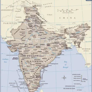
Premium Framed Print : Map of India 1896


![]()
Framed Photos from Fine Art Storehouse
Map of India 1896
Andres Allgemeiner Handatlas - Bielefeld und Leipzig 1896
Unleash your creativity and transform your space into a visual masterpiece!
THEPALMER
Media ID 18357077
14"x16" Premium Frame
Contemporary style Premium Wooden Frame with 8"x10" Print. Complete with 2" White Mat and 1.25" thick MDF frame. Printed on 260 gsm premium paper. Glazed with shatter proof UV coated acrylic glass. Backing is paper covered backing with rubber bumpers. Supplied ready to hang with a pre-installed sawtooth/wire hanger. Care Instructions: Spot clean with a damp cloth. Securely packaged in a clear plastic bag and envelope in a reinforced cardboard shipper
FSC Real Wood Frame and Double Mounted with White Conservation Mountboard - Professionally Made and Ready to Hang
Estimated Image Size (if not cropped) is 25.4cm x 20.3cm (10" x 8")
Estimated Product Size is 40.6cm x 35.6cm (16" x 14")
These are individually made so all sizes are approximate
Artwork printed orientated as per the preview above, with landscape (horizontal) orientation to match the source image.
FEATURES IN THESE COLLECTIONS
> Fine Art Storehouse
> Map
> Historical Maps
> Asia
> India
> Related Images
> Maps and Charts
> India
> Maps and Charts
> Related Images
EDITORS COMMENTS
This print showcases a remarkable piece of history - the "Map of India 1896" from Andres Allgemeiner Handatlas. This exquisite map, published in Bielefeld und Leipzig in 1896, offers a fascinating glimpse into the intricate details and vastness of India during that era. The fine craftsmanship and attention to detail are evident as you explore this vintage map. Every contour, river, and city is meticulously depicted, transporting you back to a time when cartography was an art form. The delicate color palette adds depth and richness to the overall composition, enhancing its visual appeal. As you study this historical artifact closely, it becomes apparent how much has changed over the years. It serves as a reminder of India's diverse landscapes, cultural heritage, and geopolitical boundaries at the turn of the 19th century. "The Map of India 1896" by THEPALMER is not just an aesthetically pleasing artwork but also an educational tool that invites viewers to delve into the past. Whether you have personal ties to India or simply appreciate historical maps, this print will undoubtedly spark curiosity and prompt further exploration. Displaying this print in your home or office will not only add a touch of sophistication but also serve as a conversation starter for those who appreciate both artistry and history. Immerse yourself in nostalgia with this extraordinary piece from Fine Art Storehouse!
MADE IN THE USA
Safe Shipping with 30 Day Money Back Guarantee
FREE PERSONALISATION*
We are proud to offer a range of customisation features including Personalised Captions, Color Filters and Picture Zoom Tools
SECURE PAYMENTS
We happily accept a wide range of payment options so you can pay for the things you need in the way that is most convenient for you
* Options may vary by product and licensing agreement. Zoomed Pictures can be adjusted in the Cart.