Poster Print > Asia > India > Maps
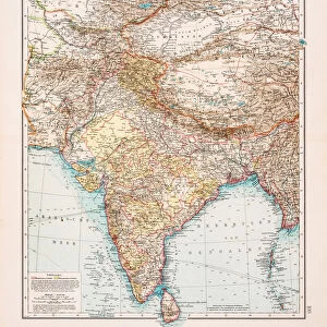
Poster Print : Map of India 1896


![]()
Poster Prints from Fine Art Storehouse
Map of India 1896
Andres Allgemeiner Handatlas - Bielefeld und Leipzig 1896
Unleash your creativity and transform your space into a visual masterpiece!
THEPALMER
Media ID 18357077
18x24 inch Poster Print
Step back in time with our exquisite Map of India 1896 print from ThePalmer at Media Storehouse. This captivating piece, taken from Andres Allgemeiner Handatlas published in Bielefeld and Leipzig in 1896, showcases a detailed and intriguing representation of India during that era. Ideal for history enthusiasts, world travelers, or anyone seeking to add a touch of vintage charm to their home or office decor. Our high-quality poster prints preserve the rich historical details and vibrant colors of the original map, ensuring a stunning addition to your collection.
Poster prints are budget friendly enlarged prints in standard poster paper sizes. Printed on 150 gsm Matte Paper for a natural feel and supplied rolled in a tube. Great for framing and should last many years. To clean wipe with a microfiber, non-abrasive cloth or napkin. Our Archival Quality Photo Prints and Fine Art Paper Prints are printed on higher quality paper and the choice of which largely depends on your budget.
Poster prints are budget friendly enlarged prints in standard poster paper sizes (A0, A1, A2, A3 etc). Whilst poster paper is sometimes thinner and less durable than our other paper types, they are still ok for framing and should last many years. Our Archival Quality Photo Prints and Fine Art Paper Prints are printed on higher quality paper and the choice of which largely depends on your budget.
Estimated Product Size is 61.6cm x 46.3cm (24.3" x 18.2")
These are individually made so all sizes are approximate
Artwork printed orientated as per the preview above, with landscape (horizontal) orientation to match the source image.
FEATURES IN THESE COLLECTIONS
> Fine Art Storehouse
> Map
> Historical Maps
> Asia
> India
> Related Images
> Maps and Charts
> India
> Maps and Charts
> Related Images
EDITORS COMMENTS
This print showcases a remarkable piece of history - the "Map of India 1896" from Andres Allgemeiner Handatlas. This exquisite map, published in Bielefeld und Leipzig in 1896, offers a fascinating glimpse into the intricate details and vastness of India during that era. The fine craftsmanship and attention to detail are evident as you explore this vintage map. Every contour, river, and city is meticulously depicted, transporting you back to a time when cartography was an art form. The delicate color palette adds depth and richness to the overall composition, enhancing its visual appeal. As you study this historical artifact closely, it becomes apparent how much has changed over the years. It serves as a reminder of India's diverse landscapes, cultural heritage, and geopolitical boundaries at the turn of the 19th century. "The Map of India 1896" by THEPALMER is not just an aesthetically pleasing artwork but also an educational tool that invites viewers to delve into the past. Whether you have personal ties to India or simply appreciate historical maps, this print will undoubtedly spark curiosity and prompt further exploration. Displaying this print in your home or office will not only add a touch of sophistication but also serve as a conversation starter for those who appreciate both artistry and history. Immerse yourself in nostalgia with this extraordinary piece from Fine Art Storehouse!
MADE IN THE USA
Safe Shipping with 30 Day Money Back Guarantee
FREE PERSONALISATION*
We are proud to offer a range of customisation features including Personalised Captions, Color Filters and Picture Zoom Tools
SECURE PAYMENTS
We happily accept a wide range of payment options so you can pay for the things you need in the way that is most convenient for you
* Options may vary by product and licensing agreement. Zoomed Pictures can be adjusted in the Cart.