Premium Framed Print > Asia > Palestine > Maps
Premium Framed Print : Antique map of Palestine and Phoenicia


![]()
Framed Photos From Fine Art Storehouse
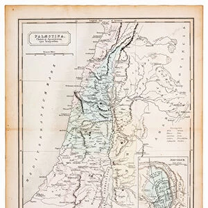
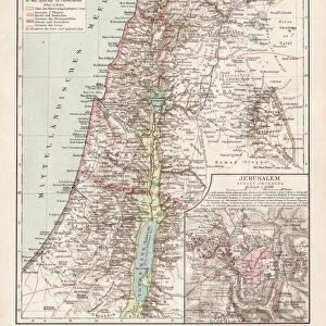
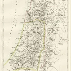
Antique map of Palestine and Phoenicia
Illustration of a antique map of Palestine and Phoenicia
Unleash your creativity and transform your space into a visual masterpiece!
Nastasic
Media ID 21086481
14"x18" Premium Frame
Contemporary style Premium Wooden Frame with 8"x12" Print. Complete with 2" White Mat and 1.25" thick MDF frame. Printed on 260 gsm premium paper. Glazed with shatter proof UV coated acrylic glass. Backing is paper covered backing with rubber bumpers. Supplied ready to hang with a pre-installed sawtooth/wire hanger. Care Instructions: Spot clean with a damp cloth. Securely packaged in a clear plastic bag and envelope in a reinforced cardboard shipper
FSC Real Wood Frame and Double Mounted with White Conservation Mountboard - Professionally Made and Ready to Hang
Estimated Image Size (if not cropped) is 20.3cm x 30.4cm (8" x 12")
Estimated Product Size is 35.6cm x 45.8cm (14" x 18")
These are individually made so all sizes are approximate
Artwork printed orientated as per the preview above, with portrait (vertical) orientation to match the source image.
FEATURES IN THESE COLLECTIONS
> Fine Art Storehouse
> Map
> Historical Maps
> Asia
> Palestine
> Related Images
> Maps and Charts
> Related Images
EDITORS COMMENTS
This print showcases an exquisite antique map of Palestine and Phoenicia, taking us on a mesmerizing journey through time. Created by the talented artist Nastasic, this illustration is a true testament to the beauty and intricacy of cartography. The map transports us back to a bygone era, where explorers and adventurers embarked on daring voyages in search of new lands. Every detail meticulously etched onto this piece tells a story of ancient civilizations, trade routes, and cultural exchange. As we gaze upon this remarkable artwork, we are transported to the vibrant landscapes that once flourished in these historical regions. The delicate lines trace the contours of mountains, rivers, and coastlines with precision and artistry. It is as if we can almost feel the warm Mediterranean breeze against our skin. Beyond its aesthetic appeal lies a wealth of knowledge waiting to be discovered. This antique map serves as both an educational tool for history enthusiasts and an artistic masterpiece for those who appreciate fine craftsmanship. Whether displayed in your study or living room, this print will undoubtedly become a conversation starter among guests. Its timeless charm effortlessly blends into any decor style while adding depth and character to your space. Allow yourself to get lost within the intricate details of this antique map – let it ignite your imagination as you embark on your own personal exploration through time.
MADE IN THE USA
Safe Shipping with 30 Day Money Back Guarantee
FREE PERSONALISATION*
We are proud to offer a range of customisation features including Personalised Captions, Color Filters and Picture Zoom Tools
SECURE PAYMENTS
We happily accept a wide range of payment options so you can pay for the things you need in the way that is most convenient for you
* Options may vary by product and licensing agreement. Zoomed Pictures can be adjusted in the Basket.