Metal Print > Asia > Palestine > Maps
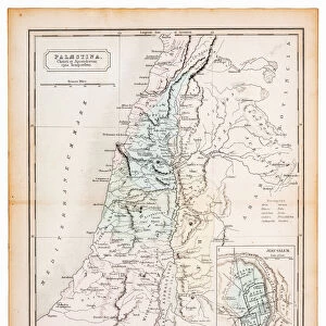
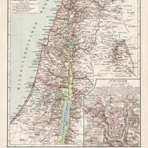
Metal Print : Antique map of Palestine and Phoenicia

![]()
Metal Prints From Fine Art Storehouse
Antique map of Palestine and Phoenicia
Illustration of a antique map of Palestine and Phoenicia
Unleash your creativity and transform your space into a visual masterpiece!
Nastasic
Media ID 21086481
16"x24" (61x41cm) Metal Print
Step back in time with our exquisite Metal Print of the Antique Map of Palestine and Phoenicia by Nastasic, from our Media Storehouse Fine Art collection. This intricately detailed map transports you to ancient civilizations with its vintage charm. The antique map is meticulously reproduced onto a high-quality metal sheet, giving it a unique, three-dimensional effect that adds depth and texture to your space. The vibrant colors and rich details pop against the sleek, modern metal surface, making it a stunning addition to any room. Bring history into your home with this beautiful and distinctive work of art.
Made with durable metal and luxurious printing techniques, our metal photo prints go beyond traditional canvases, adding a cool, modern touch to your space. Wall mount on back. Eco-friendly 100% post-consumer recycled ChromaLuxe aluminum surface. The thickness of the print is 0.045". Featuring a Scratch-resistant surface and Rounded corners. Backing hangers are attached to the back of the print and float the print 1/2-inch off the wall when hung, the choice of hanger may vary depending on size and International orders will come with Float Mount hangers only. Finished with a brilliant white high gloss surface for unsurpassed detail and vibrance. Printed using Dye-Sublimation and for best care we recommend a non-ammonia glass cleaner, water, or isopropyl (rubbing) alcohol to prevent harming the print surface. We recommend using a clean, lint-free cloth to wipe off the print. The ultra-hard surface is scratch-resistant, waterproof and weatherproof. Avoid direct sunlight exposure.
Made with durable metal and luxurious printing techniques, metal prints bring images to life and add a modern touch to any space
Estimated Product Size is 41.2cm x 61.5cm (16.2" x 24.2")
These are individually made so all sizes are approximate
Artwork printed orientated as per the preview above, with portrait (vertical) orientation to match the source image.
FEATURES IN THESE COLLECTIONS
> Fine Art Storehouse
> Map
> Historical Maps
> Asia
> Palestine
> Related Images
> Maps and Charts
> Related Images
EDITORS COMMENTS
This print showcases an exquisite antique map of Palestine and Phoenicia, taking us on a mesmerizing journey through time. Created by the talented artist Nastasic, this illustration is a true testament to the beauty and intricacy of cartography. The map transports us back to a bygone era, where explorers and adventurers embarked on daring voyages in search of new lands. Every detail meticulously etched onto this piece tells a story of ancient civilizations, trade routes, and cultural exchange. As we gaze upon this remarkable artwork, we are transported to the vibrant landscapes that once flourished in these historical regions. The delicate lines trace the contours of mountains, rivers, and coastlines with precision and artistry. It is as if we can almost feel the warm Mediterranean breeze against our skin. Beyond its aesthetic appeal lies a wealth of knowledge waiting to be discovered. This antique map serves as both an educational tool for history enthusiasts and an artistic masterpiece for those who appreciate fine craftsmanship. Whether displayed in your study or living room, this print will undoubtedly become a conversation starter among guests. Its timeless charm effortlessly blends into any decor style while adding depth and character to your space. Allow yourself to get lost within the intricate details of this antique map – let it ignite your imagination as you embark on your own personal exploration through time.
MADE IN THE USA
Safe Shipping with 30 Day Money Back Guarantee
FREE PERSONALISATION*
We are proud to offer a range of customisation features including Personalised Captions, Color Filters and Picture Zoom Tools
SECURE PAYMENTS
We happily accept a wide range of payment options so you can pay for the things you need in the way that is most convenient for you
* Options may vary by product and licensing agreement. Zoomed Pictures can be adjusted in the Basket.