Premium Framed Print > Europe > Denmark > Maps
Premium Framed Print : Antique map of Denmark


![]()
Framed Photos from Fine Art Storehouse
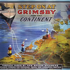
Antique map of Denmark
Unleash your creativity and transform your space into a visual masterpiece!
Hemera Technologies
Media ID 13597669
© Getty Images
Border Country Decorative Denmark Document Geography Latitude Longitude Nation National North Sea Ornamental Ornate Peninsula
14"x16" Premium Frame
Contemporary style Premium Wooden Frame with 8"x10" Print. Complete with 2" White Mat and 1.25" thick MDF frame. Printed on 260 gsm premium paper. Glazed with shatter proof UV coated acrylic glass. Backing is paper covered backing with rubber bumpers. Supplied ready to hang with a pre-installed sawtooth/wire hanger. Care Instructions: Spot clean with a damp cloth. Securely packaged in a clear plastic bag and envelope in a reinforced cardboard shipper
FSC Real Wood Frame and Double Mounted with White Conservation Mountboard - Professionally Made and Ready to Hang
Estimated Image Size (if not cropped) is 20.3cm x 25.4cm (8" x 10")
Estimated Product Size is 35.6cm x 40.6cm (14" x 16")
These are individually made so all sizes are approximate
Artwork printed orientated as per the preview above, with portrait (vertical) orientation to match the source image.
FEATURES IN THESE COLLECTIONS
> Fine Art Storehouse
> Map
> Denmark Maps
> Fine Art Storehouse
> Map
> Historical Maps
> Europe
> Denmark
> Related Images
> Europe
> Related Images
> Maps and Charts
> Early Maps
> Maps and Charts
> Related Images
EDITORS COMMENTS
This antique map of Denmark takes us on a journey through time, revealing the rich history and intricate geography of this enchanting Scandinavian nation. Crafted with meticulous attention to detail, this archival print showcases the artistry and precision of cartography from a bygone era. The ornate borders and decorative elements add an air of elegance to this vintage piece, making it not just a practical tool but also a work of art. The vibrant colors bring life to the map, highlighting Denmark's position as a peninsula surrounded by the majestic North Sea. As we explore every latitude and longitude on this historic document, we are transported back in time to when maps were meticulously hand-drawn and served as invaluable tools for navigation and discovery. This vertical composition captures the essence of Denmark's physical geography while offering glimpses into its national identity. With no people in sight, we are left alone with our thoughts to ponder upon centuries past. The photograph beautifully captures both the history embedded within these lines and the natural beauty that has shaped Denmark throughout its existence. Whether displayed in your study or living room, this antique map is sure to spark conversations about travel, culture, and heritage. It serves as a reminder that even in today's digital age, there is still immense value in preserving historical artifacts like these – tangible pieces that connect us with our pasts while inspiring future explorations.
MADE IN THE USA
Safe Shipping with 30 Day Money Back Guarantee
FREE PERSONALISATION*
We are proud to offer a range of customisation features including Personalised Captions, Color Filters and Picture Zoom Tools
SECURE PAYMENTS
We happily accept a wide range of payment options so you can pay for the things you need in the way that is most convenient for you
* Options may vary by product and licensing agreement. Zoomed Pictures can be adjusted in the Cart.