Premium Framed Print > Europe > United Kingdom > Northern Ireland > Maps
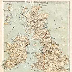
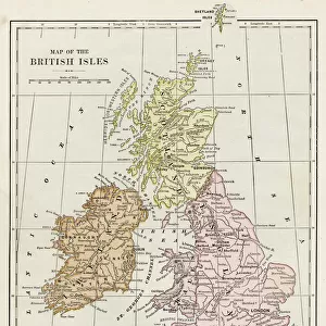
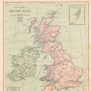
Premium Framed Print : Map of British Isles 1897


![]()
Framed Photos From Fine Art Storehouse
Map of British Isles 1897
Map of British Isles
Unleash your creativity and transform your space into a visual masterpiece!
THEPALMER
Media ID 13613577
© Roberto A Sanchez
Backgrounds British Culture Frame Grunge Grunge Image Technique Island Northern Ireland Paper Patina Republic Of Ireland Scotland Stained Textured Effect Obsolete Retro Styled
14"x16" Premium Frame
Contemporary style Premium Wooden Frame with 8"x10" Print. Complete with 2" White Mat and 1.25" thick MDF frame. Printed on 260 gsm premium paper. Glazed with shatter proof UV coated acrylic glass. Backing is paper covered backing with rubber bumpers. Supplied ready to hang with a pre-installed sawtooth/wire hanger. Care Instructions: Spot clean with a damp cloth. Securely packaged in a clear plastic bag and envelope in a reinforced cardboard shipper
FSC Real Wood Frame and Double Mounted with White Conservation Mountboard - Professionally Made and Ready to Hang
Estimated Image Size (if not cropped) is 20.3cm x 25.4cm (8" x 10")
Estimated Product Size is 35.6cm x 40.6cm (14" x 16")
These are individually made so all sizes are approximate
Artwork printed orientated as per the preview above, with portrait (vertical) orientation to match the source image.
FEATURES IN THESE COLLECTIONS
> Europe
> Republic of Ireland
> Maps
> Europe
> Republic of Ireland
> Related Images
> Europe
> United Kingdom
> England
> Maps
> Europe
> United Kingdom
> Maps
> Europe
> United Kingdom
> Northern Ireland
> Maps
> Europe
> United Kingdom
> Northern Ireland
> Posters
> Europe
> United Kingdom
> Northern Ireland
> Related Images
> Europe
> United Kingdom
> Scotland
> Maps
> Europe
> United Kingdom
> Scotland
> Posters
> Europe
> United Kingdom
> Scotland
> Related Images
EDITORS COMMENTS
This print takes us back in time to the year 1897, offering a glimpse into the intricate cartography of the British Isles. The retro-styled map showcases an obsolete yet enchanting engraved image, evoking a sense of nostalgia and historical significance. The stained and textured effect adds character to this framed piece, further enhancing its vintage appeal. The Map of British Isles 1897 is a testament to the artistry and craftsmanship that went into creating such detailed physical geography representations. It beautifully captures the essence of British culture with its depiction of England, Scotland, Northern Ireland, Republic of Ireland, and other surrounding islands. The grunge image technique employed by THEPALMER lends an intriguing patina-like quality to this photograph. Its vertical composition allows for easy display on any wall or surface, making it a versatile addition to any space. While devoid of people in its frame, this artwork speaks volumes about history and heritage. It serves as a reminder of how far we have come while honoring our roots. Whether you are an avid collector or simply appreciate fine photography, this unique print will transport you back in time and ignite your imagination with stories from days gone by.
MADE IN THE USA
Safe Shipping with 30 Day Money Back Guarantee
FREE PERSONALISATION*
We are proud to offer a range of customisation features including Personalised Captions, Color Filters and Picture Zoom Tools
SECURE PAYMENTS
We happily accept a wide range of payment options so you can pay for the things you need in the way that is most convenient for you
* Options may vary by product and licensing agreement. Zoomed Pictures can be adjusted in the Basket.