Premium Framed Print > Europe > Italy > Emilia-Romagna > Ravenna
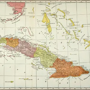
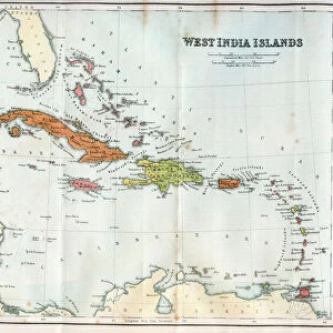
Premium Framed Print : Geography Atlas: representation of the Bahamas islands, northern Hispaniola (Santo Domingo) and the Leewind Passage between Cuba and Hispaniola in the West Indies. Map from an atlas of 1802. Biblioteca Jose Marti, Havana, Cuba
 and the Leewind Passage between Cuba and Hispaniola in the West Indies. Map from an atlas of 1802. Biblioteca Jose Marti, Havana, Cuba")
 and the Leewind Passage between Cuba and Hispaniola in the West Indies. Map from an atlas of 1802. Biblioteca Jose Marti, Havana, Cuba")


![]()
Framed Photos From Fine Art Finder
Geography Atlas: representation of the Bahamas islands, northern Hispaniola (Santo Domingo) and the Leewind Passage between Cuba and Hispaniola in the West Indies. Map from an atlas of 1802. Biblioteca Jose Marti, Havana, Cuba
VEN5031335 Geography Atlas: representation of the Bahamas islands, northern Hispaniola (Santo Domingo) and the Leewind Passage between Cuba and Hispaniola in the West Indies. Map from an atlas of 1802. Biblioteca Jose Marti, Havana, Cuba.; (add.info.: Geography Atlas: representation of the Bahamas islands, northern Hispaniola (Santo Domingo) and the Leewind Passage between Cuba and Hispaniola in the West Indies. Map from an atlas of 1802. Biblioteca Jose Marti, Havana, Cuba.); Photo © Marco Ravenna
Media ID 38484848
© © Marco Ravenna / Bridgeman Images
Amerique Centrale Amerique Du Nord Caraïbes Caribbean Caribbean Island Carte Geographique Central America Dominium Etats Unis Geographie Haiti Saint Domingue Stockravenna Geographical Map
14"x18" Premium Frame
Contemporary style Premium Wooden Frame with 8"x12" Print. Complete with 2" White Mat and 1.25" thick MDF frame. Printed on 260 gsm premium paper. Glazed with shatter proof UV coated acrylic glass. Backing is paper covered backing with rubber bumpers. Supplied ready to hang with a pre-installed sawtooth/wire hanger. Care Instructions: Spot clean with a damp cloth. Securely packaged in a clear plastic bag and envelope in a reinforced cardboard shipper
FSC Real Wood Frame and Double Mounted with White Conservation Mountboard - Professionally Made and Ready to Hang
Estimated Image Size (if not cropped) is 30.4cm x 20.3cm (12" x 8")
Estimated Product Size is 45.8cm x 35.6cm (18" x 14")
These are individually made so all sizes are approximate
Artwork printed orientated as per the preview above, with landscape (horizontal) orientation to match the source image.
FEATURES IN THESE COLLECTIONS
> Europe
> Italy
> Emilia-Romagna
> Ravenna
> Maps and Charts
> Early Maps
> Maps and Charts
> Related Images
> North America
> The Bahamas
> Maps
> North America
> The Bahamas
> Related Images
> North America
> Cuba
> Cuba Heritage Sites
> Old Havana and its Fortification System
> North America
> Cuba
> Havana
> North America
> Cuba
> Maps
> North America
> Cuba
> Related Images
EDITORS COMMENTS
This stunning print captures a piece of history from an atlas of 1802, showcasing the Geography Atlas representation of the Bahamas islands, northern Hispaniola (Santo Domingo), and the Leewind Passage between Cuba and Hispaniola in the West Indies. The intricate details on this map provide a glimpse into the geographical landscape of these Caribbean islands during the 19th century.
Displayed at Biblioteca Jose Marti in Havana, Cuba, this map serves as a valuable historical artifact that offers insight into the early exploration and colonization of Central America. The engraving beautifully illustrates the topography and boundaries of these regions, shedding light on their dominium and significance in shaping American history.
As we gaze upon this image, we are transported back in time to an era when cartographers meticulously charted uncharted territories with precision and dedication. The vibrant colors and intricate lines on this map evoke a sense of wonder and curiosity about our world's past.
Whether you are a history enthusiast or simply appreciate fine art photography, this print by Marco Ravenna is sure to spark your imagination and ignite your passion for exploring different cultures and landscapes. Let it serve as a reminder of how far we have come in understanding our planet's diverse geography while also honoring those who paved the way for future generations to continue learning about our world.
MADE IN THE USA
Safe Shipping with 30 Day Money Back Guarantee
FREE PERSONALISATION*
We are proud to offer a range of customisation features including Personalised Captions, Color Filters and Picture Zoom Tools
SECURE PAYMENTS
We happily accept a wide range of payment options so you can pay for the things you need in the way that is most convenient for you
* Options may vary by product and licensing agreement. Zoomed Pictures can be adjusted in the Basket.