Premium Framed Print > Europe > Poland > Maps
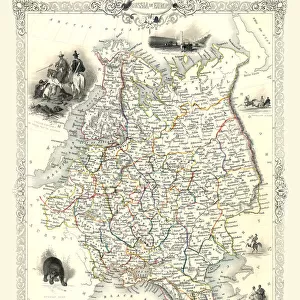
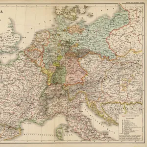
Premium Framed Print : Map of Poland includes portions of Livonia and Grand Duchy of Moscow par Chatelain, Henri Abraham (1684-1743). Etching, watercolour, 1714, Private Collection
. Etching, watercolour, 1714, Private Collection")

. Etching, watercolour, 1714, Private Collection")


![]()
Framed Photos From Fine Art Finder
Map of Poland includes portions of Livonia and Grand Duchy of Moscow par Chatelain, Henri Abraham (1684-1743). Etching, watercolour, 1714, Private Collection
FIA5405768 Map of Poland includes portions of Livonia and Grand Duchy of Moscow par Chatelain, Henri Abraham (1684-1743). Etching, watercolour, 1714, Private Collection by Chatelain, Henri Abraham (1684-1743); Private Collection; Photo © Fine Art Images
Media ID 25175896
© Fine Art Images / Bridgeman Images
Blazon Poland Polish Pole Geographical Map
14"x16" Premium Frame
Contemporary style Premium Wooden Frame with 8"x10" Print. Complete with 2" White Mat and 1.25" thick MDF frame. Printed on 260 gsm premium paper. Glazed with shatter proof UV coated acrylic glass. Backing is paper covered backing with rubber bumpers. Supplied ready to hang with a pre-installed sawtooth/wire hanger. Care Instructions: Spot clean with a damp cloth. Securely packaged in a clear plastic bag and envelope in a reinforced cardboard shipper
FSC Real Wood Frame and Double Mounted with White Conservation Mountboard - Professionally Made and Ready to Hang
Estimated Image Size (if not cropped) is 25.4cm x 20.3cm (10" x 8")
Estimated Product Size is 40.6cm x 35.6cm (16" x 14")
These are individually made so all sizes are approximate
Artwork printed orientated as per the preview above, with landscape (horizontal) orientation to match the source image.
FEATURES IN THESE COLLECTIONS
> Fine Art Finder
> Artists
> Francois-Anne David
> Fine Art Finder
> Artists
> Henri Abraham Chatelain
> Europe
> Poland
> Related Images
> Maps and Charts
> Related Images
EDITORS COMMENTS
This print showcases a remarkable historical artifact - the "Map of Poland includes portions of Livonia and Grand Duchy of Moscow" by Henri Abraham Chatelain. Created in 1714, this etching and watercolor masterpiece is now part of a private collection. The map itself is a testament to the intricate artistry and meticulous attention to detail that was characteristic of 18th-century cartography. It depicts not only the geographical boundaries but also captures the political landscape of its time, including regions such as Livonia and the Grand Duchy of Moscow. Chatelain's expertise shines through in his use of vibrant colors, bringing life to an otherwise utilitarian document. The blazoned coat-of-arms adds an air of grandeur, symbolizing Poland's rich heritage. As we gaze upon this work, we are transported back in time, gaining insight into the geopolitical complexities that shaped Europe during this era. It serves as a visual reminder that history is not merely confined within textbooks; it can be experienced through art. Thanks to Fine Art Images' exceptional photography skills, every brushstroke and hue are captured with utmost precision. This print allows us to appreciate Chatelain's mastery from afar while preserving its beauty for generations to come. Whether you are an avid historian or simply captivated by art's ability to transcend time, this stunning image offers a glimpse into both Poland's past and Chatelain's artistic brilliance.
MADE IN THE USA
Safe Shipping with 30 Day Money Back Guarantee
FREE PERSONALISATION*
We are proud to offer a range of customisation features including Personalised Captions, Color Filters and Picture Zoom Tools
SECURE PAYMENTS
We happily accept a wide range of payment options so you can pay for the things you need in the way that is most convenient for you
* Options may vary by product and licensing agreement. Zoomed Pictures can be adjusted in the Basket.