Photographic Print > Europe > Poland > Maps
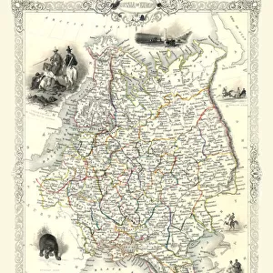
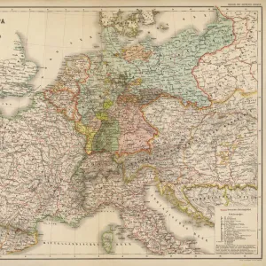
Photographic Print : Map of Poland includes portions of Livonia and Grand Duchy of Moscow par Chatelain, Henri Abraham (1684-1743). Etching, watercolour, 1714, Private Collection
. Etching, watercolour, 1714, Private Collection")

![]()
Photo Prints From Fine Art Finder
Map of Poland includes portions of Livonia and Grand Duchy of Moscow par Chatelain, Henri Abraham (1684-1743). Etching, watercolour, 1714, Private Collection
FIA5405768 Map of Poland includes portions of Livonia and Grand Duchy of Moscow par Chatelain, Henri Abraham (1684-1743). Etching, watercolour, 1714, Private Collection by Chatelain, Henri Abraham (1684-1743); Private Collection; Photo © Fine Art Images
Media ID 25175896
© Fine Art Images / Bridgeman Images
Blazon Poland Polish Pole Geographical Map
10"x8" Photo Print
Discover the rich history of Poland and its neighboring regions with this exquisite antique map from the Media Storehouse range. Dating back to 1714, this etching and watercolor masterpiece by Henri Abraham Chatelain provides a detailed and captivating representation of Poland, including portions of Livonia and the Grand Duchy of Moscow. This rare and intricately-detailed map is a must-have for history enthusiasts, collectors, and those with a passion for the art of cartography. Bring a piece of historical significance and visual charm into your home or office with this beautiful and authentic work from the Fine Art Finder collection by Bridgeman Images.
Photo prints are produced on Kodak professional photo paper resulting in timeless and breath-taking prints which are also ideal for framing. The colors produced are rich and vivid, with accurate blacks and pristine whites, resulting in prints that are truly timeless and magnificent. Whether you're looking to display your prints in your home, office, or gallery, our range of photographic prints are sure to impress. Dimensions refers to the size of the paper in inches.
Our Photo Prints are in a large range of sizes and are printed on Archival Quality Paper for excellent colour reproduction and longevity. They are ideal for framing (our Framed Prints use these) at a reasonable cost. Alternatives include cheaper Poster Prints and higher quality Fine Art Paper, the choice of which is largely dependant on your budget.
Estimated Product Size is 25.4cm x 20.3cm (10" x 8")
These are individually made so all sizes are approximate
Artwork printed orientated as per the preview above, with landscape (horizontal) orientation to match the source image.
FEATURES IN THESE COLLECTIONS
> Europe
> Poland
> Related Images
> Maps and Charts
> Related Images
EDITORS COMMENTS
This print showcases a remarkable historical artifact - the "Map of Poland includes portions of Livonia and Grand Duchy of Moscow" by Henri Abraham Chatelain. Created in 1714, this etching and watercolor masterpiece is now part of a private collection. The map itself is a testament to the intricate artistry and meticulous attention to detail that was characteristic of 18th-century cartography. It depicts not only the geographical boundaries but also captures the political landscape of its time, including regions such as Livonia and the Grand Duchy of Moscow. Chatelain's expertise shines through in his use of vibrant colors, bringing life to an otherwise utilitarian document. The blazoned coat-of-arms adds an air of grandeur, symbolizing Poland's rich heritage. As we gaze upon this work, we are transported back in time, gaining insight into the geopolitical complexities that shaped Europe during this era. It serves as a visual reminder that history is not merely confined within textbooks; it can be experienced through art. Thanks to Fine Art Images' exceptional photography skills, every brushstroke and hue are captured with utmost precision. This print allows us to appreciate Chatelain's mastery from afar while preserving its beauty for generations to come. Whether you are an avid historian or simply captivated by art's ability to transcend time, this stunning image offers a glimpse into both Poland's past and Chatelain's artistic brilliance.
MADE IN THE USA
Safe Shipping with 30 Day Money Back Guarantee
FREE PERSONALISATION*
We are proud to offer a range of customisation features including Personalised Captions, Color Filters and Picture Zoom Tools
SECURE PAYMENTS
We happily accept a wide range of payment options so you can pay for the things you need in the way that is most convenient for you
* Options may vary by product and licensing agreement. Zoomed Pictures can be adjusted in the Basket.