Premium Framed Print > Arts > Artists > B > Joan Blaeu
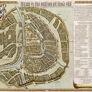
Premium Framed Print : The Moscow Kremlin Map of the 16th century (Castellum Urbis Moskvae), c. 1600 (engraving & w/c)
, c. 1600 (engraving & w / c)")

, c. 1600 (engraving & w / c)")


![]()
Framed Photos From Fine Art Finder
The Moscow Kremlin Map of the 16th century (Castellum Urbis Moskvae), c. 1600 (engraving & w/c)
7305377 The Moscow Kremlin Map of the 16th century (Castellum Urbis Moskvae), c.1600 (engraving & w/c) by Blaeu, Joan (1596-1673); Private Collection; Photo © Fine Art Images
Media ID 28382492
© Fine Art Images / Bridgeman Images
Joan Blaeu Dutch Netherlands Hollander Hollanders Netherland Netherlands Holland Dutch The Netherland
14"x16" Premium Frame
Contemporary style Premium Wooden Frame with 8"x10" Print. Complete with 2" White Mat and 1.25" thick MDF frame. Printed on 260 gsm premium paper. Glazed with shatter proof UV coated acrylic glass. Backing is paper covered backing with rubber bumpers. Supplied ready to hang with a pre-installed sawtooth/wire hanger. Care Instructions: Spot clean with a damp cloth. Securely packaged in a clear plastic bag and envelope in a reinforced cardboard shipper
FSC Real Wood Frame and Double Mounted with White Conservation Mountboard - Professionally Made and Ready to Hang
Estimated Image Size (if not cropped) is 25.4cm x 20.3cm (10" x 8")
Estimated Product Size is 40.6cm x 35.6cm (16" x 14")
These are individually made so all sizes are approximate
Artwork printed orientated as per the preview above, with landscape (horizontal) orientation to match the source image.
FEATURES IN THESE COLLECTIONS
> Fine Art Finder
> Artists
> Camille Pissarro
> Fine Art Finder
> Artists
> Joan Blaeu
> Arts
> Artists
> B
> Joan Blaeu
> Arts
> Artists
> Related Images
> Europe
> Netherlands
> Maps
> Europe
> Netherlands
> Posters
> Europe
> Netherlands
> Related Images
> Maps and Charts
> Early Maps
> Maps and Charts
> Netherlands
> Maps and Charts
> Related Images
The Moscow Kremlin Map of the 16th century - A Glimpse into Russia's Rich History
EDITORS COMMENTS
. This print showcases "The Moscow Kremlin Map of the 16th century (Castellum Urbis Moskvae)" a remarkable piece created by Joan Blaeu in around 1600. The map, an engraving with watercolor accents, offers a fascinating glimpse into the historical cityscape of Moscow during this period. Blaeu, a renowned Dutch cartographer and artist, meticulously captured the intricate details of the city's architecture and layout. From towering cathedrals to fortified walls and bustling streets, every element is depicted with precision and artistry. The vibrant watercolors add depth and life to this snapshot from centuries past. As we explore this masterpiece, we are transported back in time to early 17th-century Russia. We can imagine what it was like to wander through these streets as they were then – witnessing daily life unfold amidst grandeur and history. This artwork not only serves as a visual delight but also holds immense historical significance. It provides invaluable insights into urban planning, architectural styles prevalent at that time, and even cultural aspects that shaped Moscow's identity. "The Moscow Kremlin Map" is truly a treasure trove for history enthusiasts who seek to understand Russia's rich heritage. Its presence in private collections ensures its preservation for future generations to appreciate and learn from. Through this print from Fine Art Finder by Bridgeman Images, we have the privilege of experiencing
MADE IN THE USA
Safe Shipping with 30 Day Money Back Guarantee
FREE PERSONALISATION*
We are proud to offer a range of customisation features including Personalised Captions, Color Filters and Picture Zoom Tools
SECURE PAYMENTS
We happily accept a wide range of payment options so you can pay for the things you need in the way that is most convenient for you
* Options may vary by product and licensing agreement. Zoomed Pictures can be adjusted in the Basket.