Premium Framed Print > Europe > Spain > Maps
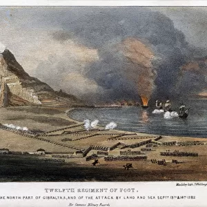
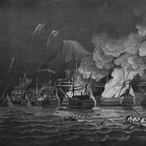
Premium Framed Print : 19Th Century Map Of The Rock Of Gibraltar


![]()
Framed Photos From Design Pics
19Th Century Map Of The Rock Of Gibraltar
Design Pics offers Distinctively Different Imagery representing over 1,500 contributors
Media ID 18181505
© Ken Welsh / Design Pics
Cartography Geographical Geography Gibraltar Mapmaking Spain Strait Straits Algeciras Iberia
14"x18" Premium Frame
Contemporary style Premium Wooden Frame with 8"x12" Print. Complete with 2" White Mat and 1.25" thick MDF frame. Printed on 260 gsm premium paper. Glazed with shatter proof UV coated acrylic glass. Backing is paper covered backing with rubber bumpers. Supplied ready to hang with a pre-installed sawtooth/wire hanger. Care Instructions: Spot clean with a damp cloth. Securely packaged in a clear plastic bag and envelope in a reinforced cardboard shipper
FSC Real Wood Frame and Double Mounted with White Conservation Mountboard - Professionally Made and Ready to Hang
Estimated Image Size (if not cropped) is 20.3cm x 30.4cm (8" x 12")
Estimated Product Size is 35.6cm x 45.8cm (14" x 18")
These are individually made so all sizes are approximate
Artwork printed orientated as per the preview above, with portrait (vertical) orientation to match the source image.
FEATURES IN THESE COLLECTIONS
> Maps and Charts
> Related Images
> Maps and Charts
> Spain
EDITORS COMMENTS
This stunning 19th-century map of the Rock of Gibraltar takes us on a captivating journey through time. With its intricate details and vibrant colors, it offers a glimpse into the artistry and precision of cartography during this era. The vertical composition allows for an immersive experience, as if we are standing at the edge of the bay, gazing upon this majestic rock formation. The map showcases not only the geographical features but also highlights key landmarks such as Algeciras and the Strait of Gibraltar. It serves as a reminder of the historical significance that this region holds, acting as a gateway between Europe and Africa. Ken Welsh's masterful print captures every nuance with remarkable clarity, transporting us back to an age when mapmaking was both science and art. Each stroke reveals meticulous attention to detail, bringing life to every contour line and coastline. As we admire this piece, we can't help but marvel at how far our understanding of geography has come since then. Yet there is something enchanting about these old maps that continues to captivate our imagination. Whether you're a history enthusiast or simply appreciate fine craftsmanship, this 19th-century map print will undoubtedly add character and charm to any space it adorns. Let it be a conversation starter or an invitation to explore new horizons – its timeless beauty is sure to leave an indelible mark on your surroundings.
MADE IN THE USA
Safe Shipping with 30 Day Money Back Guarantee
FREE PERSONALISATION*
We are proud to offer a range of customisation features including Personalised Captions, Color Filters and Picture Zoom Tools
SECURE PAYMENTS
We happily accept a wide range of payment options so you can pay for the things you need in the way that is most convenient for you
* Options may vary by product and licensing agreement. Zoomed Pictures can be adjusted in the Basket.