Poster Print > North America > Dominican Republic > Maps
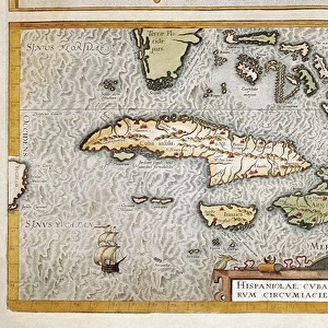
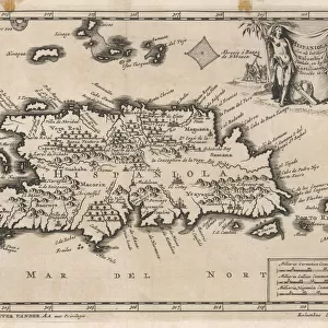
Poster Print : Map / W Indies / Hispaniola


![]()
Poster Prints from Mary Evans Picture Library
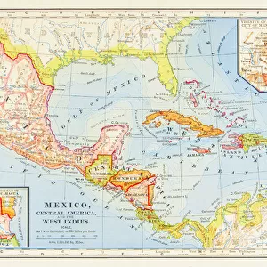
Map / W Indies / Hispaniola
The island of Hispaniola, now occupied by Haiti to the west, the Dominican Republic to the east
Mary Evans Picture Library makes available wonderful images created for people to enjoy over the centuries
Media ID 605682
© Mary Evans Picture Library 2015 - https://copyrighthub.org/s0/hub1/creation/maryevans/MaryEvansPictureID/10053550
1706 Dominican Haiti Hispaniola Indies Maps Occupied
18x24 inch Poster Print
Discover the rich history and culture of the Caribbean with our stunning selection of Map / W Indies / Hispaniola poster prints from Mary Evans Picture Library. This captivating image showcases the beautiful island of Hispaniola, the largest island in the Greater Antilles, divided into two distinct countries - Haiti to the west and the Dominican Republic to the east. Bring a piece of the Caribbean into your home or office with this high-quality, vibrant print. Order now and transport yourself to the heart of the West Indies.
Poster prints are budget friendly enlarged prints in standard poster paper sizes. Printed on 150 gsm Matte Paper for a natural feel and supplied rolled in a tube. Great for framing and should last many years. To clean wipe with a microfiber, non-abrasive cloth or napkin. Our Archival Quality Photo Prints and Fine Art Paper Prints are printed on higher quality paper and the choice of which largely depends on your budget.
Poster prints are budget friendly enlarged prints in standard poster paper sizes (A0, A1, A2, A3 etc). Whilst poster paper is sometimes thinner and less durable than our other paper types, they are still ok for framing and should last many years. Our Archival Quality Photo Prints and Fine Art Paper Prints are printed on higher quality paper and the choice of which largely depends on your budget.
Estimated Product Size is 61.6cm x 46.3cm (24.3" x 18.2")
These are individually made so all sizes are approximate
Artwork printed orientated as per the preview above, with landscape (horizontal) orientation to match the source image.
FEATURES IN THESE COLLECTIONS
> Maps and Charts
> Early Maps
> Maps and Charts
> Related Images
> North America
> Dominican Republic
> Maps
> North America
> Dominican Republic
> Related Images
> North America
> Haiti
> Maps
> North America
> Haiti
> Related Images
EDITORS COMMENTS
This print showcases a historical map of the West Indies, specifically focusing on the island of Hispaniola. The island is divided between Haiti to the west and the Dominican Republic to the east, making it a unique and culturally rich destination in the Caribbean.
Dating back to 1706, this map provides a fascinating glimpse into the history of this region, highlighting its importance in both colonial times and modern day. The intricate details and markings on the map offer insight into how this island was perceived and utilized by explorers and settlers centuries ago.
The vibrant colors and intricate design of this print make it a stunning piece of art that would be perfect for any history buff or lover of cartography. Whether you have a personal connection to Hispaniola or simply appreciate its significance in world history, this print is sure to spark curiosity and conversation.
Mary Evans Picture Library has once again curated an exceptional piece that not only educates but also captivates viewers with its beauty. Add this unique map print to your collection today and let it transport you back in time to explore the rich heritage of Hispaniola.
MADE IN THE USA
Safe Shipping with 30 Day Money Back Guarantee
FREE PERSONALISATION*
We are proud to offer a range of customisation features including Personalised Captions, Color Filters and Picture Zoom Tools
SECURE PAYMENTS
We happily accept a wide range of payment options so you can pay for the things you need in the way that is most convenient for you
* Options may vary by product and licensing agreement. Zoomed Pictures can be adjusted in the Cart.