Photographic Print > North America > Dominican Republic > Maps
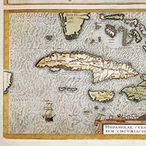
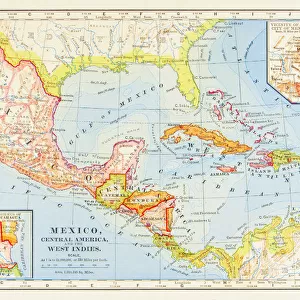
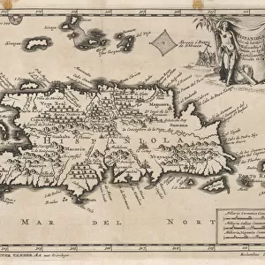
Photographic Print : Map / W Indies / Hispaniola


![]()
Photo Prints from Mary Evans Picture Library
Map / W Indies / Hispaniola
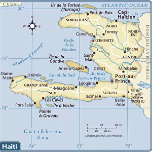
The island of Hispaniola, now occupied by Haiti to the west, the Dominican Republic to the east
Mary Evans Picture Library makes available wonderful images created for people to enjoy over the centuries
Media ID 605682
© Mary Evans Picture Library 2015 - https://copyrighthub.org/s0/hub1/creation/maryevans/MaryEvansPictureID/10053550
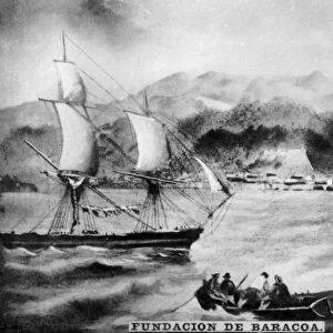
1706 Dominican Haiti Hispaniola Indies Maps Occupied
10"x8" Photo Print
Discover the rich history and beauty of the Caribbean with our exquisite "Map / W Indies / Hispaniola" print from Mary Evans Picture Library. This captivating photograph transports you back in time, showcasing the stunning island of Hispaniola, once the center of exploration and discovery in the New World. The intricate detail of the map design highlights the islands of Haiti and the Dominican Republic, separated by the mighty Massif Central mountain range. A perfect addition to any home or office, this photographic print adds a touch of history and cultural charm to your space. Bring the stories of the past to life with this beautiful and intriguing piece from our Media Storehouse collection.
Photo prints are produced on Kodak professional photo paper resulting in timeless and breath-taking prints which are also ideal for framing. The colors produced are rich and vivid, with accurate blacks and pristine whites, resulting in prints that are truly timeless and magnificent. Whether you're looking to display your prints in your home, office, or gallery, our range of photographic prints are sure to impress. Dimensions refers to the size of the paper in inches.
Our Photo Prints are in a large range of sizes and are printed on Archival Quality Paper for excellent colour reproduction and longevity. They are ideal for framing (our Framed Prints use these) at a reasonable cost. Alternatives include cheaper Poster Prints and higher quality Fine Art Paper, the choice of which is largely dependant on your budget.
Estimated Image Size (if not cropped) is 25.4cm x 17.7cm (10" x 7")
Estimated Product Size is 25.4cm x 20.3cm (10" x 8")
These are individually made so all sizes are approximate
Artwork printed orientated as per the preview above, with landscape (horizontal) orientation to match the source image.
FEATURES IN THESE COLLECTIONS
> Maps and Charts
> Early Maps
> Maps and Charts
> Related Images
> North America
> Dominican Republic
> Maps
> North America
> Dominican Republic
> Related Images
> North America
> Haiti
> Maps
> North America
> Haiti
> Related Images
EDITORS COMMENTS
This print showcases a historical map of the West Indies, specifically focusing on the island of Hispaniola. The island is divided between Haiti to the west and the Dominican Republic to the east, making it a unique and culturally rich destination in the Caribbean.
Dating back to 1706, this map provides a fascinating glimpse into the history of this region, highlighting its importance in both colonial times and modern day. The intricate details and markings on the map offer insight into how this island was perceived and utilized by explorers and settlers centuries ago.
The vibrant colors and intricate design of this print make it a stunning piece of art that would be perfect for any history buff or lover of cartography. Whether you have a personal connection to Hispaniola or simply appreciate its significance in world history, this print is sure to spark curiosity and conversation.
Mary Evans Picture Library has once again curated an exceptional piece that not only educates but also captivates viewers with its beauty. Add this unique map print to your collection today and let it transport you back in time to explore the rich heritage of Hispaniola.
MADE IN THE USA
Safe Shipping with 30 Day Money Back Guarantee
FREE PERSONALISATION*
We are proud to offer a range of customisation features including Personalised Captions, Color Filters and Picture Zoom Tools
SECURE PAYMENTS
We happily accept a wide range of payment options so you can pay for the things you need in the way that is most convenient for you
* Options may vary by product and licensing agreement. Zoomed Pictures can be adjusted in the Cart.