Poster Print > Africa > Related Images
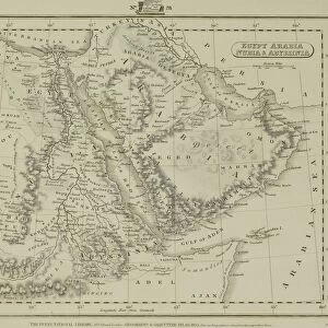
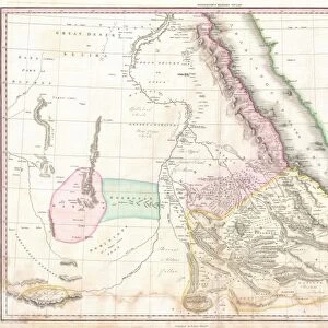
Poster Print : Map Egypt and Sudan


![]()
Poster Prints From Mary Evans Picture Library
Map Egypt and Sudan
Map covering the area from the Nile delta to the Mountains of the Moon. Zambia and the Zaire river are marked. Date: 16th century
Mary Evans Picture Library makes available wonderful images created for people to enjoy over the centuries
Media ID 14113533
© Mary Evans Picture Library
Area Covering Delta Maps Marked Moon Nile Sudan Zaire Zambia
18x24 inch Poster Print
"Discover the rich history and cultural wonders of Egypt and Sudan with our stunning Map Egypt and Sudan poster print from Media Storehouse. This exquisite map, dating back to the 16th century, offers a captivating glimpse into the past, depicting the Nile Delta, the Sahara Desert, and the major rivers and landmarks of the region, including the Zaire River and the Mountains of the Moon. This beautifully detailed and intricately designed map, sourced from Mary Evans Prints Online, is an essential addition for history enthusiasts, educators, and anyone with an appreciation for the beauty of historical cartography. Bring a piece of the past into your home or office with our high-quality poster print."
Poster prints are budget friendly enlarged prints in standard poster paper sizes. Printed on 150 gsm Matte Paper for a natural feel and supplied rolled in a tube. Great for framing and should last many years. To clean wipe with a microfiber, non-abrasive cloth or napkin. Our Archival Quality Photo Prints and Fine Art Paper Prints are printed on higher quality paper and the choice of which largely depends on your budget.
Poster prints are budget friendly enlarged prints in standard poster paper sizes (A0, A1, A2, A3 etc). Whilst poster paper is sometimes thinner and less durable than our other paper types, they are still ok for framing and should last many years. Our Archival Quality Photo Prints and Fine Art Paper Prints are printed on higher quality paper and the choice of which largely depends on your budget.
Estimated Product Size is 46.3cm x 61.6cm (18.2" x 24.3")
These are individually made so all sizes are approximate
Artwork printed orientated as per the preview above, with portrait (vertical) orientation to match the source image.
MADE IN THE USA
Safe Shipping with 30 Day Money Back Guarantee
FREE PERSONALISATION*
We are proud to offer a range of customisation features including Personalised Captions, Color Filters and Picture Zoom Tools
FREE COLORIZATION SERVICE
You can choose advanced AI Colorization for this picture at no extra charge!
SECURE PAYMENTS
We happily accept a wide range of payment options so you can pay for the things you need in the way that is most convenient for you
* Options may vary by product and licensing agreement. Zoomed Pictures can be adjusted in the Basket.