Fraud Blocker Skip to main content

Pillow > Africa > Related Images

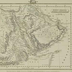
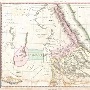
Pillow : Map Egypt and Sudan

Map Egypt and Sudan


We accept all major credit cards


Framed Photos
Photo Prints
Jigsaw Puzzles
Poster Prints
Canvas Prints
Fine Art Prints
Metal Prints
Home Decor


Mary Evans Prints Online

Home Decor From Mary Evans Picture Library

Map Egypt and Sudan

Map covering the area from the Nile delta to the Mountains of the Moon. Zambia and the Zaire river are marked. Date: 16th century

Mary Evans Picture Library makes available wonderful images created for people to enjoy over the centuries

Media ID 14113533

© Mary Evans Picture Library

Area Covering Delta Maps Marked Moon Nile Sudan Zaire Zambia


18"x18" (46x46cm) Pillow

18"x18" (46x46cm) Faux Suede Pillow with a plush soft feel. Your choice of image fills the front, with a stone colored faux suede back. Flat sewn concealed white zip.

Accessorise your space with decorative, soft pillows

Estimated Product Size is 45.7cm x 45.7cm (18" x 18")

These are individually made so all sizes are approximate

Artwork printed orientated as per the preview above, with landscape (horizontal) or portrait (vertical) orientation to match the source image.


MADE IN THE USA
Safe Shipping with 30 Day Money Back Guarantee

FREE PERSONALISATION*
We are proud to offer a range of customisation features including Personalised Captions, Color Filters and Picture Zoom Tools

FREE COLORIZATION SERVICE
You can choose advanced AI Colorization for this picture at no extra charge!

SECURE PAYMENTS
We happily accept a wide range of payment options so you can pay for the things you need in the way that is most convenient for you

* Options may vary by product and licensing agreement. Zoomed Pictures can be adjusted in the Basket.


public
Made in USA
loyalty
Includes Free Shipping
price_check
Bulk discounts at checkout
thumb_up
Professional quality finish
diamond
Made with high-grade materials
inventory_2
Carefully packed to aid safe arrival


Related Images


Battle of the Falkland Islands by G. H. Davis
Antique map of Middle East with Arabia, Egypt, Nubia, and Abyssinia
MAP: CHINA, 1931. Map of the Republic of China. Lithograph, 1931
MAP: FAIRYLAND, c1920. Imaginary map of Fairyland. Drawing by Bernard Sleigh, c1920
Victorian Map of Africa
Map of Egypt
Map of Egypt
1771, Bonne Map of Abyssinia, Ethiopia, Sudan and the Red Sea, Rigobert Bonne 1727 - 1794
1818, Pinkerton Map of Nubia, Sudan and Abyssinia, John Pinkerton, 1758 - 1826, Scottish
Harrods advert world map, c. 1909
Comparative ranges of fighter aircraft by G. H. Davis
The Battlefield of Gettysburg
Ranges of RAF bombers by G. H. Davis

+

Shipping

+

Choices

+

Reviews

+

Guaranteed