Poster Print > Aerial Photography > Related Images
Poster Print : Psg25 Technique for Vertical Or Plan Mapping Aerial Phot?


![]()
Poster Prints From Mary Evans Picture Library
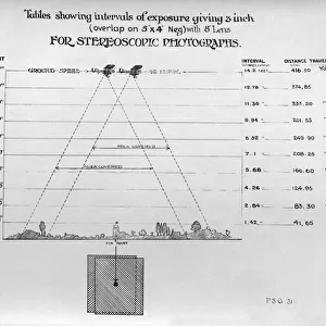
Psg25 Technique for Vertical Or Plan Mapping Aerial Phot?
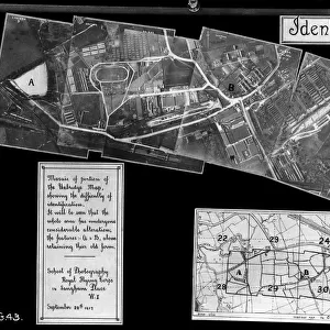
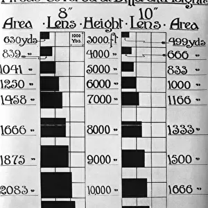
Psg25 Technique for Vertical Or Plan Mapping Aerial Photography to Avoid Bad Results - Straight and Level Or Banking - Early Years of Aerial-Photography History - Instructions Date: 1910s
Mary Evans Picture Library makes available wonderful images created for people to enjoy over the centuries
Media ID 18412862
© aviation-images.com / Mary Evans Picture Library
Air To Ground Archive Days Histories Olden Past Rafaerial
27x27 inch Poster Print
Step back in time with our vintage poster print from the Media Storehouse collection. This captivating image showcases the Psg25 Technique for Vertical or Plan Mapping Aerial Photography, an essential method used in the early years of aerial photography history. With instructions dating back to the 1910s, this print offers a fascinating glimpse into the past of aviation and photography. This rights-managed print from Mary Evans Prints Online adds a touch of historical charm to any room, making it an excellent addition to your decor. Perfect for aviation enthusiasts, historians, or anyone who appreciates the beauty of vintage photography.
Poster prints are budget friendly enlarged prints in standard poster paper sizes. Printed on 150 gsm Matte Paper for a natural feel and supplied rolled in a tube. Great for framing and should last many years. To clean wipe with a microfiber, non-abrasive cloth or napkin. Our Archival Quality Photo Prints and Fine Art Paper Prints are printed on higher quality paper and the choice of which largely depends on your budget.
Poster prints are budget friendly enlarged prints in standard poster paper sizes (A0, A1, A2, A3 etc). Whilst poster paper is sometimes thinner and less durable than our other paper types, they are still ok for framing and should last many years. Our Archival Quality Photo Prints and Fine Art Paper Prints are printed on higher quality paper and the choice of which largely depends on your budget.
Estimated Product Size is 69.2cm x 69.2cm (27.2" x 27.2")
These are individually made so all sizes are approximate
Artwork printed orientated as per the preview above, with landscape (horizontal) or portrait (vertical) orientation to match the source image.
FEATURES IN THESE COLLECTIONS
> Mary Evans Prints Online
> Aviation Images
> Aerial Photography
> Related Images
MADE IN THE USA
Safe Shipping with 30 Day Money Back Guarantee
FREE PERSONALISATION*
We are proud to offer a range of customisation features including Personalised Captions, Color Filters and Picture Zoom Tools
FREE COLORIZATION SERVICE
You can choose advanced AI Colorization for this picture at no extra charge!
SECURE PAYMENTS
We happily accept a wide range of payment options so you can pay for the things you need in the way that is most convenient for you
* Options may vary by product and licensing agreement. Zoomed Pictures can be adjusted in the Basket.