Poster Print > Europe > United Kingdom > England > London > Towns > Mill Hill
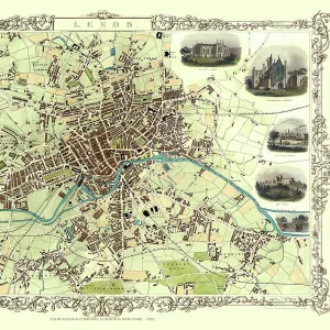
Poster Print : Old Map of Leeds 1851 by John Tallis


![]()
Poster Prints from MapSeeker
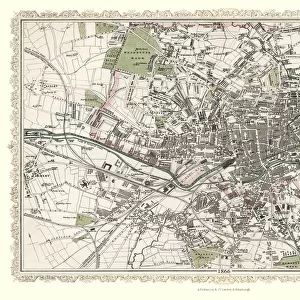
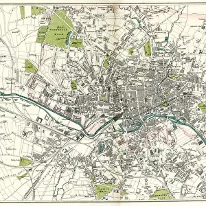
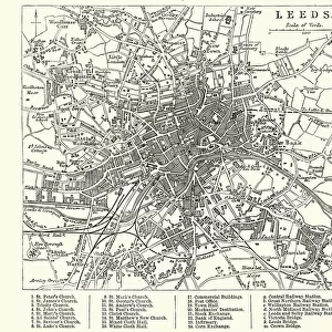
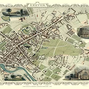
Old Map of Leeds 1851 by John Tallis
This map of Leeds in West Yorkshire by John Tallis 1851 features the districts of Woodhouse Carr, Great Woodhouse, Little London, New Town, Little Woodhouse, New Wortley, Holbeck, and Hunslet. The plan is finished with illustrations of Mill Hill Chapel, Kirkstall Abbey, Wellington Bridge, New Gaol, Woodhouse Cemetry, Town Hall and St Peters Church as well as a canal view
Welcome to the Mapseeker Image library and enter an historic gateway to one of the largest on-line collections of Historic Maps, Nostalgic Views, Vista's and Panorama's from a World gone by.
Media ID 20347580
Historic Map John Tallis John Tallis Map Old Town Plan Tallis Map Leeds
18x24 inch Poster Print
Discover the rich history of Leeds with our stunning Old Map of Leeds 1851 by John Tallis print from Media Storehouse. This captivating poster transport you back in time, showcasing the districts of Woodhouse Carr, Great Woodhouse, Little London, New Town, Little Woodhouse, New Wortley, Holbeck, and Hunslet as they appeared over 170 years ago. Perfect for history enthusiasts, local residents, or anyone with a love for vintage maps, this beautifully detailed and authentic reproduction is a must-have addition to your home or office. Bring a piece of Leeds' past into your present with Media Storehouse's Old Map of Leeds 1851 by John Tallis print.
Poster prints are budget friendly enlarged prints in standard poster paper sizes. Printed on 150 gsm Matte Paper for a natural feel and supplied rolled in a tube. Great for framing and should last many years. To clean wipe with a microfiber, non-abrasive cloth or napkin. Our Archival Quality Photo Prints and Fine Art Paper Prints are printed on higher quality paper and the choice of which largely depends on your budget.
Poster prints are budget friendly enlarged prints in standard poster paper sizes (A0, A1, A2, A3 etc). Whilst poster paper is sometimes thinner and less durable than our other paper types, they are still ok for framing and should last many years. Our Archival Quality Photo Prints and Fine Art Paper Prints are printed on higher quality paper and the choice of which largely depends on your budget.
Estimated Product Size is 61.6cm x 46.3cm (24.3" x 18.2")
These are individually made so all sizes are approximate
Artwork printed orientated as per the preview above, with landscape (horizontal) orientation to match the source image.
FEATURES IN THESE COLLECTIONS
> MapSeeker
> British Town And City Plans
> English & Welsh PORTFOLIO
> Animals
> Mammals
> Muridae
> Peters Mouse
> Arts
> Artists
> H
> John Hillers
> Arts
> Artists
> H
> John Hills
> Arts
> Artists
> T
> John Tallis
> Europe
> United Kingdom
> England
> London
> Towns
> Mill Hill
> Europe
> United Kingdom
> England
> London
> Towns
> Welling
> Europe
> United Kingdom
> England
> London
> Towns
> West Hill
> Europe
> United Kingdom
> England
> West Yorkshire
> Leeds
> Europe
> United Kingdom
> England
> West Yorkshire
> Related Images
> Europe
> United Kingdom
> England
> Yorkshire
> Holbeck
EDITORS COMMENTS
This print showcases the "Old Map of Leeds 1851" by John Tallis, offering a fascinating glimpse into the city's rich history. The meticulously detailed map highlights various districts including Woodhouse Carr, Great Woodhouse, Little London, New Town, Little Woodhouse, New Wortley, Holbeck, and Hunslet. Immerse yourself in this beautifully illustrated plan that not only depicts the layout of Leeds but also features iconic landmarks such as Mill Hill Chapel, Kirkstall Abbey, Wellington Bridge, New Gaol (now known as Leeds Central Library), Woodhouse Cemetery, Town Hall and St Peters Church. Additionally, it offers an enchanting canal view that transports you back to a time when waterways played a vital role in transportation. As you explore this historic map of Leeds created by John Tallis in 1851 with great attention to detail and artistic flair; you'll gain a deeper appreciation for the city's evolution over time. This visual treasure is perfect for history enthusiasts or anyone seeking to connect with their roots in West Yorkshire
MADE IN THE USA
Safe Shipping with 30 Day Money Back Guarantee
FREE PERSONALISATION*
We are proud to offer a range of customisation features including Personalised Captions, Color Filters and Picture Zoom Tools
SECURE PAYMENTS
We happily accept a wide range of payment options so you can pay for the things you need in the way that is most convenient for you
* Options may vary by product and licensing agreement. Zoomed Pictures can be adjusted in the Cart.