Metal Print > Europe > United Kingdom > England > London > Towns > Mill Hill
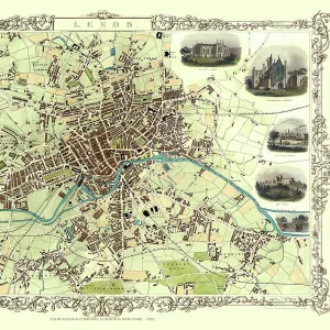
Metal Print : Old Map of Leeds 1851 by John Tallis


![]()
Metal Prints from MapSeeker
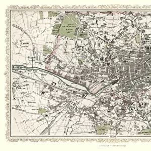
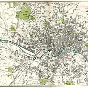
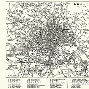
Old Map of Leeds 1851 by John Tallis
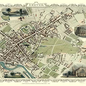
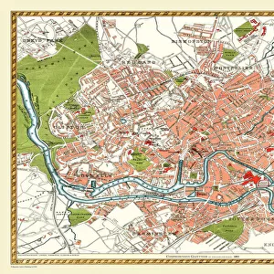
This map of Leeds in West Yorkshire by John Tallis 1851 features the districts of Woodhouse Carr, Great Woodhouse, Little London, New Town, Little Woodhouse, New Wortley, Holbeck, and Hunslet. The plan is finished with illustrations of Mill Hill Chapel, Kirkstall Abbey, Wellington Bridge, New Gaol, Woodhouse Cemetry, Town Hall and St Peters Church as well as a canal view
Welcome to the Mapseeker Image library and enter an historic gateway to one of the largest on-line collections of Historic Maps, Nostalgic Views, Vista's and Panorama's from a World gone by.
Media ID 20347580
Historic Map John Tallis John Tallis Map Old Town Plan Tallis Map Leeds
16"x24" (61x41cm) Metal Print
Step back in time with our stunning Metal Print of the Old Map of Leeds 1851 by John Tallis from MapSeeker. This unique and captivating piece showcases the historical districts of Woodhouse Carr, Great Woodhouse, Little London, New Town, Little Woodhouse, New Wortley, Holbeck, and Hunslet. Each detail is meticulously preserved, bringing the past to life in vibrant colors and sharp contrasts. The sleek, modern metal print design adds a contemporary twist to this classic map, making it a perfect addition to any home or office. Relive the history of Leeds with this beautiful and intriguing piece of art.
Made with durable metal and luxurious printing techniques, our metal photo prints go beyond traditional canvases, adding a cool, modern touch to your space. Wall mount on back. Eco-friendly 100% post-consumer recycled ChromaLuxe aluminum surface. The thickness of the print is 0.045". Featuring a Scratch-resistant surface and Rounded corners. Backing hangers are attached to the back of the print and float the print 1/2-inch off the wall when hung, the choice of hanger may vary depending on size and International orders will come with Float Mount hangers only. Finished with a brilliant white high gloss surface for unsurpassed detail and vibrance. Printed using Dye-Sublimation and for best care we recommend a non-ammonia glass cleaner, water, or isopropyl (rubbing) alcohol to prevent harming the print surface. We recommend using a clean, lint-free cloth to wipe off the print. The ultra-hard surface is scratch-resistant, waterproof and weatherproof. Avoid direct sunlight exposure.
Made with durable metal and luxurious printing techniques, metal prints bring images to life and add a modern touch to any space
Estimated Product Size is 61.5cm x 41.2cm (24.2" x 16.2")
These are individually made so all sizes are approximate
Artwork printed orientated as per the preview above, with landscape (horizontal) orientation to match the source image.
FEATURES IN THESE COLLECTIONS
> MapSeeker
> British Town And City Plans
> English & Welsh PORTFOLIO
> Animals
> Mammals
> Muridae
> Peters Mouse
> Arts
> Artists
> H
> John Hillers
> Arts
> Artists
> H
> John Hills
> Arts
> Artists
> T
> John Tallis
> Europe
> United Kingdom
> England
> London
> Towns
> Mill Hill
> Europe
> United Kingdom
> England
> London
> Towns
> Welling
> Europe
> United Kingdom
> England
> London
> Towns
> West Hill
> Europe
> United Kingdom
> England
> West Yorkshire
> Leeds
> Europe
> United Kingdom
> England
> West Yorkshire
> Related Images
> Europe
> United Kingdom
> England
> Yorkshire
> Holbeck
EDITORS COMMENTS
This print showcases the "Old Map of Leeds 1851" by John Tallis, offering a fascinating glimpse into the city's rich history. The meticulously detailed map highlights various districts including Woodhouse Carr, Great Woodhouse, Little London, New Town, Little Woodhouse, New Wortley, Holbeck, and Hunslet. Immerse yourself in this beautifully illustrated plan that not only depicts the layout of Leeds but also features iconic landmarks such as Mill Hill Chapel, Kirkstall Abbey, Wellington Bridge, New Gaol (now known as Leeds Central Library), Woodhouse Cemetery, Town Hall and St Peters Church. Additionally, it offers an enchanting canal view that transports you back to a time when waterways played a vital role in transportation. As you explore this historic map of Leeds created by John Tallis in 1851 with great attention to detail and artistic flair; you'll gain a deeper appreciation for the city's evolution over time. This visual treasure is perfect for history enthusiasts or anyone seeking to connect with their roots in West Yorkshire
MADE IN THE USA
Safe Shipping with 30 Day Money Back Guarantee
FREE PERSONALISATION*
We are proud to offer a range of customisation features including Personalised Captions, Color Filters and Picture Zoom Tools
SECURE PAYMENTS
We happily accept a wide range of payment options so you can pay for the things you need in the way that is most convenient for you
* Options may vary by product and licensing agreement. Zoomed Pictures can be adjusted in the Cart.