Poster Print > Oceania > Australia > Maps
Poster Print : Map of South Australia


![]()
Poster Prints from Heritage Images
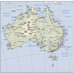
Map of South Australia
Map of South Australia. Map showing the Spencer and Vincent Gulfs, Kangaroo Island and Adelaide. Plate 110 from The Times Atlas
Heritage Images features heritage image collections
Media ID 15464462
© The Print Collector / Heritage-Images
Adelaide Australia Cartography Coastline Map Making South Australia Kangaroo Island
18x24 inch Poster Print
Discover the rich history and natural beauty of South Australia with our exquisite Map of South Australia poster print from the Media Storehouse Heritage Images collection. This captivating vintage map showcases the Spencer and Vincent Gulfs, Kangaroo Island, and Adelaide, offering a unique glimpse into the past. Bring the charm of yesteryears into your home or office decor, and transport yourself on a journey through time with every glance. Order now and let this stunning piece of cartography be a conversation starter and a source of intrigue for all who visit your space.
Poster prints are budget friendly enlarged prints in standard poster paper sizes. Printed on 150 gsm Matte Paper for a natural feel and supplied rolled in a tube. Great for framing and should last many years. To clean wipe with a microfiber, non-abrasive cloth or napkin. Our Archival Quality Photo Prints and Fine Art Paper Prints are printed on higher quality paper and the choice of which largely depends on your budget.
Poster prints are budget friendly enlarged prints in standard poster paper sizes (A0, A1, A2, A3 etc). Whilst poster paper is sometimes thinner and less durable than our other paper types, they are still ok for framing and should last many years. Our Archival Quality Photo Prints and Fine Art Paper Prints are printed on higher quality paper and the choice of which largely depends on your budget.
Estimated Product Size is 46.3cm x 61.6cm (18.2" x 24.3")
These are individually made so all sizes are approximate
Artwork printed orientated as per the preview above, with portrait (vertical) orientation to match the source image.
FEATURES IN THESE COLLECTIONS
> Maps and Charts
> Related Images
> Oceania
> Australia
> Adelaide
EDITORS COMMENTS
This print showcases a historical treasure - the Map of South Australia. With intricate details and vibrant colors, this map offers a fascinating glimpse into the geography and coastline of this beautiful region. Plate 110 from The Times Atlas, it highlights prominent features such as the Spencer and Vincent Gulfs, Kangaroo Island, and the bustling city of Adelaide. As we delve into its cartography, we are transported back in time to an era when map-making was both an art form and a scientific endeavor. This particular print is a testament to the skill and precision of those unknown cartographers who meticulously crafted this masterpiece. The coastlines depicted on this map are truly awe-inspiring; they reveal South Australia's unique blend of rugged cliffs, sandy beaches, and hidden coves waiting to be explored. One cannot help but imagine sailing along these shores or discovering secret treasures nestled within Kangaroo Island's lush landscapes. Adelaide takes center stage on this map, proudly showcasing its position as the capital city. Its streets come alive with color as we envision bustling markets, grand architecture, and a rich tapestry of cultures that have shaped its identity over time. This print is not just an artifact; it represents our connection to history and our curiosity about the world around us. It serves as a reminder that even in today's digital age, there is still something magical about holding a physical piece of art that captures both beauty and knowledge.
MADE IN THE USA
Safe Shipping with 30 Day Money Back Guarantee
FREE PERSONALISATION*
We are proud to offer a range of customisation features including Personalised Captions, Color Filters and Picture Zoom Tools
SECURE PAYMENTS
We happily accept a wide range of payment options so you can pay for the things you need in the way that is most convenient for you
* Options may vary by product and licensing agreement. Zoomed Pictures can be adjusted in the Cart.