Photo Mug > Oceania > Australia > Maps
Photo Mug : Map of South Australia


![]()
Home Decor from Heritage Images
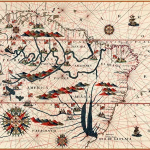
Map of South Australia
Map of South Australia. Map showing the Spencer and Vincent Gulfs, Kangaroo Island and Adelaide. Plate 110 from The Times Atlas
Heritage Images features heritage image collections
Media ID 15464462
© The Print Collector / Heritage-Images
Adelaide Australia Cartography Coastline Map Making South Australia Kangaroo Island
Large Photo Mug (15 oz)
Bring the beauty of South Australia into your daily routine with our Media Storehouse Photo Mugs. Featuring an exquisite vintage map of South Australia from The Times Atlas, these mugs showcase the stunning detail of the Spencer and Vincent Gulfs, Kangaroo Island, and Adelaide. Each mug holds your favorite beverage while allowing you to enjoy a piece of history with every sip. Perfect for travel enthusiasts, history buffs, or anyone who appreciates the charm of vintage maps. Order yours today and start your day with a touch of South Australian heritage.
Elevate your coffee or tea experience with our premium white ceramic mug. Its wide, comfortable handle makes drinking easy, and you can rely on it to be both microwave and dishwasher safe. Sold in single units, preview may show both sides of the same mug so you can see how the picture wraps around.
Elevate your coffee or tea experience with our premium white ceramic mug. Its wide, comfortable handle makes drinking easy, and you can rely on it to be both microwave and dishwasher safe. Sold in single units, preview may show both sides of the same mug so you can see how the picture wraps around.
These are individually made so all sizes are approximate
FEATURES IN THESE COLLECTIONS
> Maps and Charts
> Related Images
> Oceania
> Australia
> Adelaide
EDITORS COMMENTS
This print showcases a historical treasure - the Map of South Australia. With intricate details and vibrant colors, this map offers a fascinating glimpse into the geography and coastline of this beautiful region. Plate 110 from The Times Atlas, it highlights prominent features such as the Spencer and Vincent Gulfs, Kangaroo Island, and the bustling city of Adelaide. As we delve into its cartography, we are transported back in time to an era when map-making was both an art form and a scientific endeavor. This particular print is a testament to the skill and precision of those unknown cartographers who meticulously crafted this masterpiece. The coastlines depicted on this map are truly awe-inspiring; they reveal South Australia's unique blend of rugged cliffs, sandy beaches, and hidden coves waiting to be explored. One cannot help but imagine sailing along these shores or discovering secret treasures nestled within Kangaroo Island's lush landscapes. Adelaide takes center stage on this map, proudly showcasing its position as the capital city. Its streets come alive with color as we envision bustling markets, grand architecture, and a rich tapestry of cultures that have shaped its identity over time. This print is not just an artifact; it represents our connection to history and our curiosity about the world around us. It serves as a reminder that even in today's digital age, there is still something magical about holding a physical piece of art that captures both beauty and knowledge.
MADE IN THE USA
Safe Shipping with 30 Day Money Back Guarantee
FREE PERSONALISATION*
We are proud to offer a range of customisation features including Personalised Captions, Color Filters and Picture Zoom Tools
SECURE PAYMENTS
We happily accept a wide range of payment options so you can pay for the things you need in the way that is most convenient for you
* Options may vary by product and licensing agreement. Zoomed Pictures can be adjusted in the Cart.