Poster Print > South America > Related Images
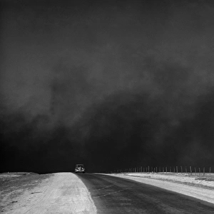
Poster Print : TEXAS: AMARILLO, 1943. Aerial view of Amarillo, Texas. Photograph by Jack Delano


![]()
Poster Prints From Granger
TEXAS: AMARILLO, 1943. Aerial view of Amarillo, Texas. Photograph by Jack Delano
TEXAS: AMARILLO, 1943.
Aerial view of Amarillo, Texas. Photograph by Jack Delano, March 1943
Granger holds millions of images spanning more than 25,000 years of world history, from before the Stone Age to the dawn of the Space Age
Media ID 13215759
1943 Aerial View Church Cityscape Delano Housing Jack March New Deal Southwest Texas Town Amarillo
18x24 inch Poster Print
Step back in time with our captivating Texas: Amarillo, 1943 poster print from Media Storehouse. This vintage photograph, taken by Jack Delano in March 1943, showcases an aerial view of Amarillo, Texas, capturing the essence of the past. The black-and-white image brilliantly highlights the city's layout, including the Pantex Army Airfield, Palo Duro Canyon, and the sprawling ranchlands. Add this historic piece to your home or office décor to create an authentic and timeless atmosphere. Granger Art on Demand's high-quality print ensures vibrant colors and sharp details, making it a must-have for history enthusiasts and those who appreciate the beauty of the past.
Poster prints are budget friendly enlarged prints in standard poster paper sizes. Printed on 150 gsm Matte Paper for a natural feel and supplied rolled in a tube. Great for framing and should last many years. To clean wipe with a microfiber, non-abrasive cloth or napkin. Our Archival Quality Photo Prints and Fine Art Paper Prints are printed on higher quality paper and the choice of which largely depends on your budget.
Poster prints are budget friendly enlarged prints in standard poster paper sizes (A0, A1, A2, A3 etc). Whilst poster paper is sometimes thinner and less durable than our other paper types, they are still ok for framing and should last many years. Our Archival Quality Photo Prints and Fine Art Paper Prints are printed on higher quality paper and the choice of which largely depends on your budget.
Estimated Product Size is 61.6cm x 46.3cm (24.3" x 18.2")
These are individually made so all sizes are approximate
Artwork printed orientated as per the preview above, with landscape (horizontal) orientation to match the source image.
FEATURES IN THESE COLLECTIONS
> Granger Art on Demand
> What's New
> South America
> Related Images
TEXAS - AMARILLO, 1943 - A Glimpse into the Heart of Southwest America
EDITORS COMMENTS
. This aerial view of Amarillo, Texas, taken by renowned photographer Jack Delano in March 1943, offers a mesmerizing snapshot of this vibrant city. The photograph showcases the bustling urban landscape with its mix of mid-century buildings and charming houses nestled amidst the vast Texan plains. The image captures the essence of Amarillo's unique character as an American town on the cusp of change. The New Deal initiatives are evident in the carefully planned housing developments that dot the cityscape, reflecting a commitment to improving living conditions for all residents during this transformative era. Amidst this evolving urban fabric stands a striking church, symbolizing faith and community at the heart of daily life. Its towering presence serves as a reminder that even amidst progress and growth, traditional values remain deeply rooted in Amarillo's identity. Delano's lens skillfully captures not only architectural details but also hints at the spirit and energy pulsating through every street corner. From here, one can almost feel the warmth emanating from homes and hear echoes of laughter drifting through open windows. This photograph is more than just a visual record; it transports us back to an era when Amarillo was poised on the brink of modernity while still preserving its Southwestern charm. It invites us to reflect upon our own connection to place and history – reminding us that cities are not merely collections of buildings but living entities shaped
MADE IN THE USA
Safe Shipping with 30 Day Money Back Guarantee
FREE PERSONALISATION*
We are proud to offer a range of customisation features including Personalised Captions, Color Filters and Picture Zoom Tools
SECURE PAYMENTS
We happily accept a wide range of payment options so you can pay for the things you need in the way that is most convenient for you
* Options may vary by product and licensing agreement. Zoomed Pictures can be adjusted in the Basket.