Poster Print > Europe > United Kingdom > England > Maps
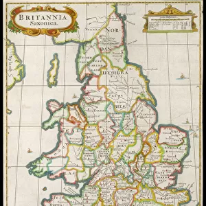
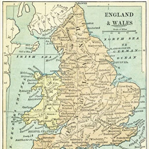
Poster Print : MAP OF ENGLAND. A map of England as it appeared in the 18th century


![]()
Poster Prints From Granger
MAP OF ENGLAND. A map of England as it appeared in the 18th century
MAP OF ENGLAND.
A map of England as it appeared in the 18th century
Granger holds millions of images spanning more than 25,000 years of world history, from before the Stone Age to the dawn of the Space Age
Media ID 12321028
18x24 inch Poster Print
Step back in time with our exquisite 18th-century Map of England print from Granger Art on Demand. This beautiful poster, part of our Media Storehouse collection, transports you back to an era of discovery and exploration. With intricate detail and vivid colors, this historical map captures the shape and boundaries of England as it existed over 300 years ago. A must-have for history enthusiasts, educators, or anyone who appreciates the beauty of historical cartography. Add this captivating piece to your home or office and let the stories of the past come alive.
Poster prints are budget friendly enlarged prints in standard poster paper sizes. Printed on 150 gsm Matte Paper for a natural feel and supplied rolled in a tube. Great for framing and should last many years. To clean wipe with a microfiber, non-abrasive cloth or napkin. Our Archival Quality Photo Prints and Fine Art Paper Prints are printed on higher quality paper and the choice of which largely depends on your budget.
Poster prints are budget friendly enlarged prints in standard poster paper sizes (A0, A1, A2, A3 etc). Whilst poster paper is sometimes thinner and less durable than our other paper types, they are still ok for framing and should last many years. Our Archival Quality Photo Prints and Fine Art Paper Prints are printed on higher quality paper and the choice of which largely depends on your budget.
Estimated Product Size is 46.3cm x 61.6cm (18.2" x 24.3")
These are individually made so all sizes are approximate
Artwork printed orientated as per the preview above, with portrait (vertical) orientation to match the source image.
FEATURES IN THESE COLLECTIONS
> Arts
> Artists
> O
> Oceanic Oceanic
> Arts
> Landscape paintings
> Waterfall and river artworks
> River artworks
> Europe
> United Kingdom
> England
> Maps
> Europe
> United Kingdom
> England
> Rivers
> Maps and Charts
> Related Images
EDITORS COMMENTS
This print showcases a remarkable piece of history - a Map of England from the 18th century. With intricate details and exquisite craftsmanship, this map takes us back in time to an era when cartography was both an art form and a scientific endeavor. The map depicts the English island nestled amidst the vastness of the Atlantic Ocean, with its borders extending all the way to the Channel. As we gaze upon this vintage treasure, we are transported to a bygone age where exploration and discovery were at their peak. Each river is meticulously drawn, flowing gracefully across the land, while cities and towns dot the landscape like tiny jewels. This map not only serves as a geographical reference but also provides insight into England's rich cultural heritage during that period. The sepia tones evoke a sense of nostalgia, reminding us of centuries past when maps were hand-drawn with utmost precision by skilled artisans. It is fascinating to imagine how these maps would have guided travelers through unfamiliar territories or inspired dreams of far-off lands. Whether you are an enthusiast for historical artifacts or simply appreciate fine artistry, this Map of England print will undoubtedly captivate your imagination. Hang it on your wall and let it transport you back in time as you explore every nook and cranny of this enchanting depiction of 18th-century England.
MADE IN THE USA
Safe Shipping with 30 Day Money Back Guarantee
FREE PERSONALISATION*
We are proud to offer a range of customisation features including Personalised Captions, Color Filters and Picture Zoom Tools
SECURE PAYMENTS
We happily accept a wide range of payment options so you can pay for the things you need in the way that is most convenient for you
* Options may vary by product and licensing agreement. Zoomed Pictures can be adjusted in the Basket.