Poster Print > Arts > Artists > O > Oceanic Oceanic
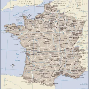
Poster Print : Map of France


![]()
Poster Prints from Fine Art Storehouse
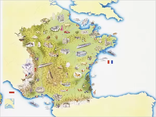
Map of France
Unleash your creativity and transform your space into a visual masterpiece!
Dorling Kindersley
Media ID 13558825
© This content is subject to copyright
Country Geography National Flag National Flags Regions Gallic
18x24 inch Poster Print
Poster prints are budget friendly enlarged prints in standard poster paper sizes. Printed on 150 gsm Matte Paper for a natural feel and supplied rolled in a tube. Great for framing and should last many years. To clean wipe with a microfiber, non-abrasive cloth or napkin. Our Archival Quality Photo Prints and Fine Art Paper Prints are printed on higher quality paper and the choice of which largely depends on your budget.
Poster prints are budget friendly enlarged prints in standard poster paper sizes (A0, A1, A2, A3 etc). Whilst poster paper is sometimes thinner and less durable than our other paper types, they are still ok for framing and should last many years. Our Archival Quality Photo Prints and Fine Art Paper Prints are printed on higher quality paper and the choice of which largely depends on your budget.
Estimated Product Size is 61.6cm x 46.3cm (24.3" x 18.2")
These are individually made so all sizes are approximate
Artwork printed orientated as per the preview above, with landscape (horizontal) orientation to match the source image.
FEATURES IN THESE COLLECTIONS
> Fine Art Storehouse
> Photo Libraries
> Dorling Kindersley Prints
> Arts
> Artists
> O
> Oceanic Oceanic
> Arts
> Landscape paintings
> Landscape art
> Landscape paintings
> Europe
> Related Images
> Maps and Charts
> Related Images
EDITORS COMMENTS
This vibrant and detailed print captures the essence of France in a single frame. The "Map of France" is an exquisite representation of this country, showcasing its diverse landscapes and rich cultural heritage. From the stunning coastline to the picturesque regions, every aspect is beautifully illustrated with precision. The colors used in this map are simply breathtaking - each region stands out vividly against the pristine white background. The coastal areas are depicted with utmost accuracy, allowing us to envision ourselves strolling along sandy beaches or gazing at the vastness of the ocean. What makes this artwork truly remarkable is how it seamlessly blends geography and national pride. National flags elegantly adorn each region, symbolizing unity amidst diversity. It serves as a reminder that despite being geographically distinct, all these regions come together under one flag - representing Gallic spirit and French identity. Dorling Kindersley has masterfully employed illustration techniques to create a visually striking piece that not only educates but also captivates viewers. This horizontal composition invites exploration as we trace our fingers across borders and delve into different parts of France's physical geography. Whether you're an avid traveler or simply appreciate fine art, this print will transport you to the enchanting world of France – a land filled with history, beauty, and endless possibilities for discovery.
MADE IN THE USA
Safe Shipping with 30 Day Money Back Guarantee
FREE PERSONALISATION*
We are proud to offer a range of customisation features including Personalised Captions, Color Filters and Picture Zoom Tools
SECURE PAYMENTS
We happily accept a wide range of payment options so you can pay for the things you need in the way that is most convenient for you
* Options may vary by product and licensing agreement. Zoomed Pictures can be adjusted in the Cart.